
Image: Cuyama River, Cuyama Valley, California (20960090394)
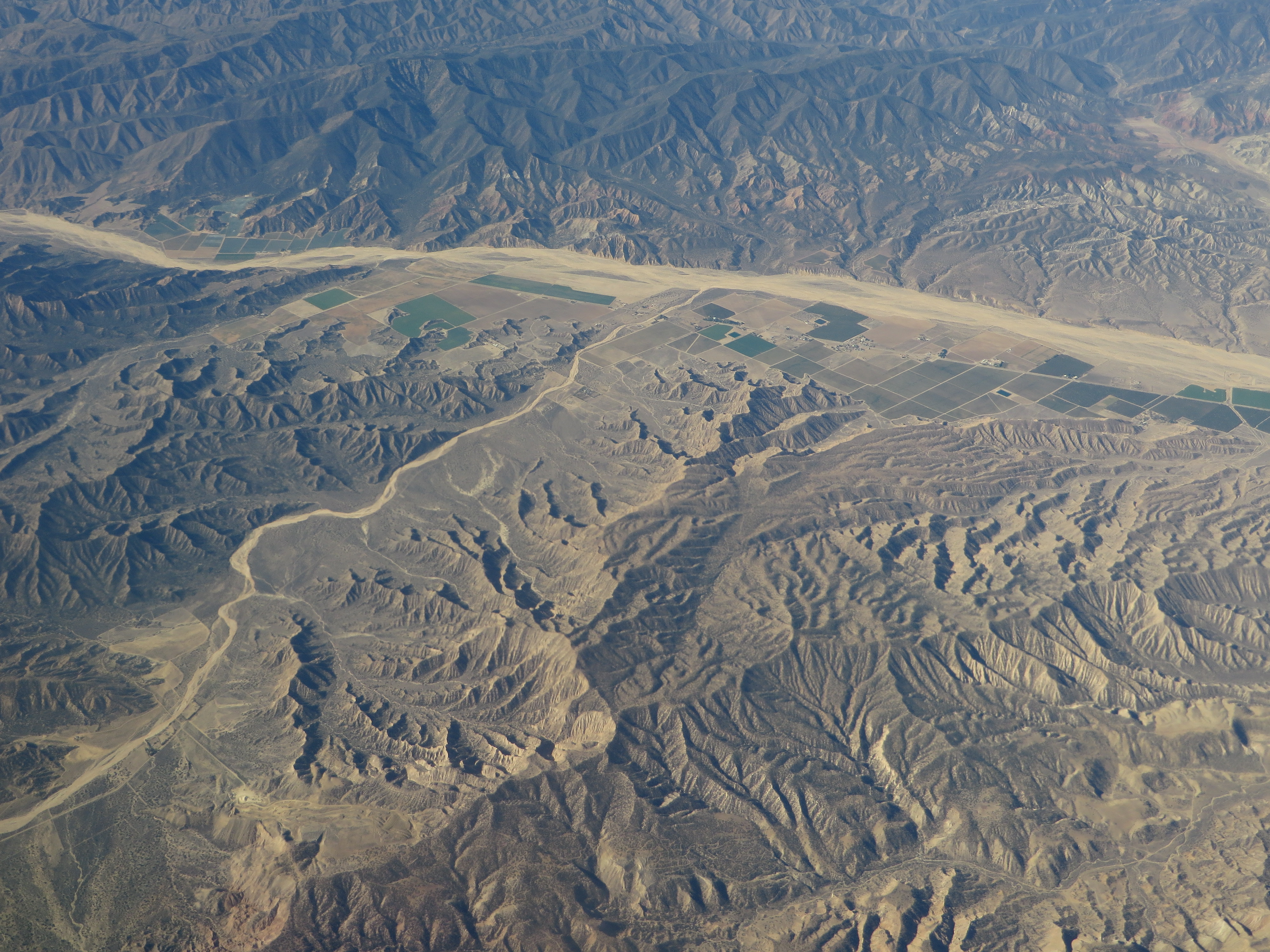
Description: The Cuyama Valley is a valley along the Cuyama River in central California, in northern Santa Barbara, southern San Luis Obispo, southwestern Kern, and northwestern Ventura counties. It is a sparsely inhabited area containing two significant towns – Cuyama and New Cuyama – and is largely used for ranching, agriculture, and oil and gas production. California State Route 166 runs along most of the length of the valley, connecting the coastal communities of Santa Maria and Arroyo Grande with the San Joaquin Valley near Bakersfield. The valley encompasses an area of approximately 300 square miles (780 km2). It is bounded on all sides by mountains, and the Cuyama River escapes west through a narrow canyon to the Pacific Ocean between the Sierra Madre Mountains on the south and the La Panza Range on the north. The headwaters of the Cuyama River are just north of Pine Mountain Summit on California State Route 33, and the valley widens from there to its maximum width near the junction of Route 166 and 33, near the corner of the four counties, and then it narrows again as the river exits to the ocean between the enclosing mountain ranges. The agricultural portions are in the center, near to the major highway intersection and the two towns, where the alluvium is rich and the valley is a wide floodplain. North of the major portion of the valley is the mile-high Caliente Range, on the other side of which is the Carrizo Plain. To the east-southeast is the high backcountry of Ventura County, which includes Mount Pinos, the highest summit in the region, and the northeastern extremity of the valley ends at the San Andreas Fault, which forms a low jumble of hills over which passes Route 166; the southern San Joaquin Valley and Bakersfield are on the other side. The Los Padres National Forest is adjacent to the Cuyama Valley on the south, east, and northwest; much of the land to the north, including most of the Caliente Range, is owned by the Bureau of Land Management (BLM). Geologically, the valley is an alluvium-filled synclinal basin, at an elevation of approximately 2,000 to 2,500 feet (600 to 800 meters). Most of the rocks are sedimentary, and the Miocene-age Monterey Formation outcrops to the south, in the foothills of the Sierra Madre. Pliocene and Pleistocene sedimentary formations occur in the foothills along the south side of the valley as well. The large Morales Thrust Fault separates the abruptly-rising block of the Caliente Range from the valley itself on the north. Scenic badlands occur in the upper reaches of the valley, north and northeast of Pine Mountain Summit; they are reachable from Route 33 via Lockwood Valley Road. The climate of the valley is semi-arid with hot summers and cool winters. Almost all precipitation occurs in the winter in the form of rain, although snow has fallen on occasion; only five inches of rain falls annually on the valley floor, making it the driest place in coastal Central California. Since the valley is open to the sea, there is occasional marine influence. The principal native vegetation on the valley floor is grassland and scrub, with chaparral and oak woodland in the hills to the south. en.wikipedia.org/wiki/Cuyama_Valley en.wikipedia.org/wiki/Wikipedia:Text_of_Creative_Commons_...
Title: Cuyama River, Cuyama Valley, California (20960090394)
Credit: Cuyama River, Cuyama Valley, California
Author: Ken Lund from Reno, Nevada, USA
Usage Terms: Creative Commons Attribution-Share Alike 2.0
License: CC BY-SA 2.0
License Link: https://creativecommons.org/licenses/by-sa/2.0
Attribution Required?: Yes
Image usage
The following page links to this image:

.jpg)