
Image: Developmental-Plan-Banks
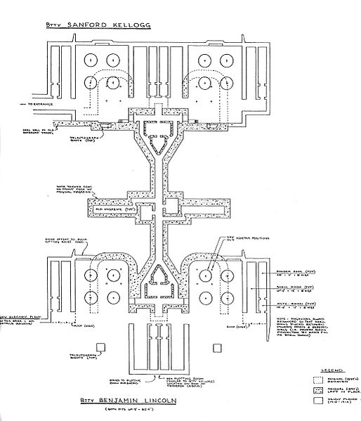
Description: This is a portion of the plan view of the two coast defense mortar batteries at Fort Banks, Winthrop, MA. Originally researched and drawn by Thomas Vaughan of the Coast Defense Study Group (and updated through December, 1982), the plan is a portion of a larger diagram that also includes elevations of the exterior of the mortar pits. The plan was drawn by Vaughan based on original plans of the batteries drawn up by the U.S. Army Engineers during the period 1891-1896 and upon piecing together notes at the National Archives for the period 1910-1917. The diagram must have involved hundreds of hours of research and drafting. This portion of the plan is abstracted from a public document dated February, 2001, being the submission by Mr. Vaughan and the Fort Banks Preservation Association to the Massachusetts Historical Commission requesting designation of the site of the batteries as part of the National Register of Historic Places. The designation was granted by the U.S. government. This plan charts the outlines of the four mortar pits, three of which are still (in 2010) visible from the surface, and also details the subterranean structure of the batteries' magazines and connecting galleries, all of which are now buried, and only some of which remain accessible. The central corridor illustrated runs almost directly east-west, with east at the top of this diagram. The two mortar pits on the left (north) side of this plan were called the "B" pits of each battery, and the ones on the right (south) side the "A" pits. Btty Kellogg Pit B is the one that has mostly been excavated and can be entered today through a gate opening on the Winthrop Dept. of Public Works parking lot (or by descending a filled-in ramp from the street that was constructed when the pit was recently excavated). Kellogg Pit A is now completely obscured by an apartment building that covers it, while both pits of Btty Lincoln have been partially filled, paved over, and are today used for parking. The plan clearly shows how the original pits, which proved to be too cramped for the service of four mortars at once, were enlarged over time. According to Vaughan, no other coast defense mortar battery in the country has this unique magazine design or apparent evidence of redesign and reconstruction of all its four pits.
Title: Developmental-Plan-Banks
Credit: This portion of the plan is abstracted from a public document dated February, 2001, being the submission by Mr. Vaughan and the Fort Banks Preservation Association to the Massachusetts Historical Commission requesting designation of the site of the batteries as part of the National Register of Historic Places. The designation was granted by the U.S. government.
Usage Terms: Public domain
License: PD
Attribution Required?: No
Image usage
The following page links to this image:
