
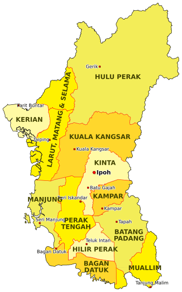
Image: Districts in Perak

Description: EN: This is the map of the districts of the Malaysian state of Perak as of 2018.
The district borders are based on the map on the Unique Parcel Identifier site, and the location of cities are approximated based on OpenStreetMap. The borders of the districts Muallim and Bagan Datuk (declared in 2016) are based on the map on the South Perak Region website.
This map is meant to only be for illustrative purposes. This map is not an authority on state district borders and should not be used for navigation.
MS: Ini adalah peta daerah-daerah di negeri Perak di Malaysia pada tahun 2018.
Sempadan-sempadan daerah didasarkan peta daripada laman Unique Parcel Identifier, dan kedudukan bandar-bandar dianggarkan berdasarkan peta OpenStreetMap. Sempadan daerah Muallim dan Bagan Datuk (diisytihar 2016) didasarkan peta di laman Wilayah Perak Selatan.
Peta ini hanya bertujuan untuk tujuan ilustratif sahaja. Ia bukannya penentu kedudukan tepat sempadan-sempadan daerah dan tidak sepatutnya digunakan untuk navigasi.
Author: SyahirSQRT2 (talk)
Usage Terms: Creative Commons Attribution-Share Alike 3.0
License: CC-BY-SA-3.0
License Link: http://creativecommons.org/licenses/by-sa/3.0/
Attribution Required?: Yes
Image usage
The following page links to this image:
