
Image: Early migrations mercator

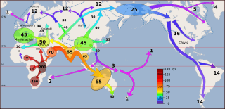
Description: Peopling of the world (recent out of Africa and Upper Paleolithic). Figures are in thousands of years ago (kya). Time is color coded in a scheme of increasing "frequency", red at 100 kya to violet at 0 kya. Dotted blueish lines are meant to indicate approximate glaciation during the LGM. Similar map: pleistoproject.wordpress.com Not shown early and abortive expansions to North Africa [300 kya] and West Asia [270 kya, 130 kya] and possible expansion to China by 120 kya. Possible "Australoid" migration to North Asia [Denisovan admixture] and the Americas by 50 kya (these are speculative/controversial and would detract from the functionality as an "overview map" showing generally-accepted scenarios). Features shown: 200 kya East Africa ["200" symbolic of early H. sapiens (est. age of mt-haplogroup L ranges around 180 kya, early divergence in Africa as early as 300 kya but cut-off for "anatomically modern" vs. "archaic" is somewhat arbitrary in this case) 130-100 kya expansion within Africa and to the Levant 70 kya "recent Out of Africa" and coastal migrations 65 kya peopling of Oceania 60 kya "Indian" and "Indochina" (Laos) population centers 50 kya "Near Eastern" population center (Emiran) 40 kya "East Asian" population center 40 kya peopling of Europe (Aurignacian 42 kya) 40 kya approximate peopling of Tasmania (add more detail on dispersal in Australia and to Papua?) 35 kya peopling of the Mammoth steppe (Mal'ta–Buret' culture 24kya) 35 kya Expansion from East Asian population center (Korea 35 kya, Japan possibly 35 kya / certainly by 14 kya, Taiwan between 30 and 20 kya, Cambodia by 20kya [Sơn Vi culture] -- but possibly earlier "Austronesian" presence 70kya?) 25 kya Beringia during the LGM 16-14 kya peopling of the Americas just after the LGM (Clovis) 12 peopling of northern Eurasia after the LGM 12 peopling of the Green Sahara [Mali] 4 Paleo-Eskimo expansion to the Arctic (AST = Arctic small tool tradition) 3-1 Austronesian expansion 1 Norse expansion to Iceland The map only shows the major movements associated with the first lasting "peopling" of the world's regions: early movements which did not result in lasting populations (such as the early Out of Africa movements before 70kya) are not shown late movements into already populated regions (such as Epipaleolithic and Neolithic migrations associated with Indo-European, Bantu, etc.) are not shown; the Austronesian (Pacific) expansion is shown even though it is much later than such Neolithic movements because it led to the "first peopling" of the Pacific islands. This might be addressed in updated versions (especially knowledge on the early OOA waves are subject to rapid revision) Made for, and based on the information in: en:Early human migrations (see also image gallery below). "Southern Dispersal" and "peopling of Eurasia" population centers: Metspalu, M.; Kivisild, T.; Metspalu, E.; Parik, J.; Hudjashov, G.; Kaldma, K.; Serk, P.; Karmin, M. et al. (2004). "Most of the extant mtDNA boundaries in south and southwest Asia were likely shaped during the initial settlement of Eurasia by anatomically modern humans". BMC Genetics 5: 26. doi:10.1186/1471-2156-5-26. PMC 516768. PMID 15339343.
Title: Early migrations mercator
Credit: Own work; Map: File:World map blank shorelines.svg (the shoreline map is Template:PD-USGov-USGS, derived from a mercator svg map posted in 2005, extracted from an original file released by pubs.usgs.gov)
Author: User:Dbachmann
Usage Terms: Creative Commons Attribution-Share Alike 4.0
License: CC BY-SA 4.0
License Link: https://creativecommons.org/licenses/by-sa/4.0
Attribution Required?: Yes
Image usage
The following 3 pages link to this image:
