
Image: East Tennessee Crossing - The Lakes of the Crossing from Clinch Mountain - NARA - 7718101

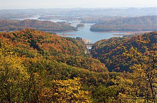
Description: Scope and content: The original finding aid described this photograph as: Original Caption: From high atop Clinch Mountain, one can see south across the forested, winding shorelines of Cherokee Lake to the misty Great Smoky Mountains in the distance, a long, serene view of a broad valley with extensive lakes stretching in all directions. This was the route and landscape through which passed the East Tennessee Crossing — the Warriors Path, the Wilderness Road, and the Dixie Highway. Location: Tennessee (36.350° N 83.394° W) Status: Public domain. Photo by Michael Sledjeski
Title: East Tennessee Crossing - The Lakes of the Crossing from Clinch Mountain
Credit: U.S. National Archives and Records Administration
Author: Unknown authorUnknown author or not provided
Usage Terms: Public domain
License: Public domain
Attribution Required?: No
Image usage
The following 2 pages link to this image:
