
Image: Eastern-Beringia-during-the-LGM-and-retreat-of-the-ice-sheets-A-Exposed-land-when-sea
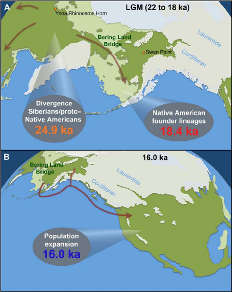
Description: Eastern Beringia during the LGM and retreat of the ice sheets. (A) Exposed land when sea levels were lowest (light green), modern-day landmass (dark green), and ice sheets (white). At the height of the LGM, the Laurentide and Cordilleran ice sheets blocked access to the Americas from eastern Beringia (that is, the Bering Land Bridge and Alaska/Yukon) (30). Populations west of the Bering Land Bridge were able to migrate southward during the LGM, but those on the Bering Land Bridge were unable to retreat farther than the Aleutian ice belt (arrows). The last point of detectable gene flow between Siberian and Native American ancestral populations (24.9 ka) and the geographic isolation marked by the formation of Native American founder lineages (18.4 ka) are shown (see Fig. 2B for details). The Yana Rhinoceros Horn site (32 ka) and the Swan Point site (14 ka) illustrate the temporal and geographic gaps in the Beringian archaeological record. (B) The ice sheets that began to retreat ~17 ka, opening a potential Pacific coastal route by ~15 ka (arrow). The rapid population expansion (16.0 ka) likely marks the movement south of the ice (see Fig. 3C for details).
Author: (2016). "Ancient mitochondrial DNA provides high-resolution time scale of the peopling of the Americas". Science Advances 2 (4). American Association for the Advancement of Science (AAAS). DOI:10.1126/sciadv.1501385. ISSN 2375-2548.
Usage Terms: Creative Commons Attribution-Share Alike 3.0
License: CC-BY-SA-3.0
License Link: http://creativecommons.org/licenses/by-sa/3.0/
Attribution Required?: Yes
Image usage
The following page links to this image:
