
Image: Edwards-Trinity aquifer system v1

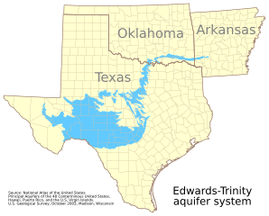
Description: This map shows the extent of the Edwards-Trinity aquifer system. It is based on GIS data from the National Atlas of the United States at http://dds.cr.usgs.gov/pub/data/nationalatlas/aquifrp025.tar.gz. The metadata provides, in part: Citation: Citation_Information: Originator: U.S. Geological Survey Publication_Date: 200310 Title: Principal Aquifers of the 48 Conterminous United States, Hawaii, Puerto Rico, and the U.S. Virgin Islands Edition: Version 1.0 Publication_Information: Publication_Place: Madison, WI, USA Publisher: U.S. Geological Survey Online_Linkage: <http://nationalatlas.gov/atlasftp.html> Description: Abstract: This map layer contains the shallowest principal aquifers of the conterminous United States, Hawaii, Puerto Rico, and the U.S. Virgin Islands, portrayed as polygons. The map layer was developed as part of the effort to produce the maps published at 1:2,500,000 in the printed series "Ground Water Atlas of the United States". The published maps contain base and cultural features not included in these data. This is a replacement for the July 1998 map layer called Principal Aquifers of the 48 Conterminous United States. Purpose: These data are intended for use in publications, at a scale of 1:2,500,000 or smaller. Due to the small scale, the primary intended use is for regional and national data display and analysis, rather than specific local data analysis. See the source data for the complete metadata. This map uses the polyconic projection centered on the west 100th meridian: "+proj=poly +lon_0=100W"
Title: Edwards-Trinity aquifer system v1
Credit: Own work
Author: Kbh3rd
Usage Terms: Creative Commons Attribution-Share Alike 3.0
License: CC BY-SA 3.0
License Link: https://creativecommons.org/licenses/by-sa/3.0
Attribution Required?: Yes
Image usage
The following page links to this image:
