
Image: Egypt-region-map-cities
No higher resolution available.
Egypt-region-map-cities.gif (314 × 374 pixels, file size: 17 KB, MIME type: image/gif)
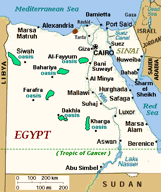
Description: Regional map of en:Egypt, with main cities and en:oasis areas labeled, plus scale of miles/km (approximate). The file is in GIF format, 10x times faster than PNG format, for rapid display and to allow precise edits when adding other towns in the future. Re-labeled to include 6 en:oasis areas, with "en:Giza" and sea-side towns, plus dotted line for en:Tropic of Cancer.
Title: Egypt-region-map-cities
Credit: en:Image:Egypt-region-map-cities.gif = File:Egypt-region-map-cities-2.gif
Author: Original: CIA Modifications: See File:Egypt-region-map-cities-2.gif
Permission: CIA WFB map
Usage Terms: Public domain
License: Public domain
Attribution Required?: No
Image usage
The following page links to this image:

All content from Kiddle encyclopedia articles (including the article images and facts) can be freely used under Attribution-ShareAlike license, unless stated otherwise.