
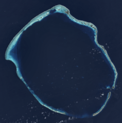
Image: Enewetak Atoll - 2014-02-10 - Landsat 8 - 15m

Size of this preview: 592 × 599 pixels. Other resolutions: 237 × 240 pixels | 2,841 × 2,876 pixels.
Original image (2,841 × 2,876 pixels, file size: 3.21 MB, MIME type: image/png)
Description: Composite "true color" multispectral satellite image of Enewetak Atoll. NASA Landsat 8 OLI bands used were 4 (red), 3 (green), 2 (blue). Pan-sharpened with band 8. Manual color balance. Projection: UTM (zone 57), WGS84. Imagery courtesy NASA/USGS.
Title: Enewetak Atoll - 2014-02-10 - Landsat 8 - 15m
Credit: NASA/USGS Landsat satellite image GeoTIFF archive, http://glovis.usgs.gov
Author: NASA
Usage Terms: Public domain
License: Public domain
Attribution Required?: No
Image usage
The following page links to this image:

All content from Kiddle encyclopedia articles (including the article images and facts) can be freely used under Attribution-ShareAlike license, unless stated otherwise.