
Image: English administrative divisions by type 2009

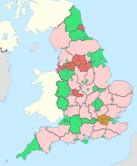
Description: Map showing the all top-tier administrative subdivisions of England (shire counties, metropolitan counties, London boroughs and Unitary Authorities) from 2009 (still valid in 2012). 00 metropolitan borough 00 London borough 00 unitary authority 00 two-tier non-metropolitan county The thicker black lines are the ceremonial county boundaries. Equirectangular map projection on WGS 84 datum, with N/S stretched 170% Geographic limits: West: 6.75W East: 2.0E North: 56.0N South: 49.75N
Title: English administrative divisions by type 2009
Credit: This file was derived from English administrative divisions 2010.svg:
Author: English_administrative_divisions_2010.svg: Nilfanion derivative work: Dr Greg
Usage Terms: Creative Commons Attribution-Share Alike 3.0
License: CC BY-SA 3.0
License Link: http://creativecommons.org/licenses/by-sa/3.0
Attribution Required?: Yes
Image usage
The following 2 pages link to this image:
