
Image: Extent map of the Adelaide Superbasin

Size of this PNG preview of this SVG file: 420 × 600 pixels. Other resolution: 168 × 240 pixels.
Original image (SVG file, nominally 512 × 731 pixels, file size: 4.8 MB)
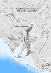
Description: This map contains shows the outline of the known (solid line) and potential (dashed line) extent of the Adelaide Superbasin in Australia on a hill-shade DEM.
Title: Extent map of the Adelaide Superbasin
Credit: Own work
Author: Jarred C Lloyd
Usage Terms: Creative Commons Attribution-Share Alike 4.0
License: CC BY-SA 4.0
License Link: https://creativecommons.org/licenses/by-sa/4.0
Attribution Required?: Yes
Image usage
The following page links to this image:

All content from Kiddle encyclopedia articles (including the article images and facts) can be freely used under Attribution-ShareAlike license, unless stated otherwise.