
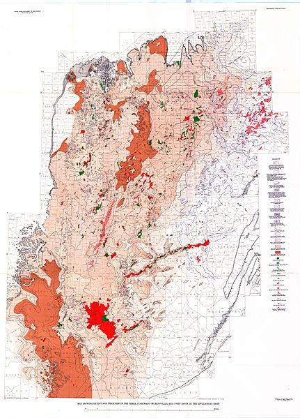
Image: Extent of Bedford Shale and Berea Sandstone - Ohio and N Kentucky

Size of this preview: 431 × 599 pixels. Other resolutions: 173 × 240 pixels | 9,750 × 13,550 pixels.
Original image (9,750 × 13,550 pixels, file size: 17.12 MB, MIME type: image/jpeg)
Description: Isopach map showing the extent of the Bedford Shale, Berea Sandstone, and associated shales and sandstones in Ohio and northern Kentucky in the United States.
Title: Extent of Bedford Shale and Berea Sandstone - Ohio and N Kentucky
Credit: https://pubs.usgs.gov/pp/0259/plate-01.pdf
Author: Pepper, James F.; DeWitt, Wallace, Jr.; Demarest, David F. (1954). Geology of the Bedford Shale and Berea Sandstone in the Appalachian Basin. Geologic Survey Professional Paper 259. Washington, D.C.: U.S. Government Printing Office, Plate 1.
Usage Terms: Public domain
License: Public domain
Attribution Required?: No
Image usage
The following page links to this image:

All content from Kiddle encyclopedia articles (including the article images and facts) can be freely used under Attribution-ShareAlike license, unless stated otherwise.