
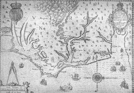
Image: First map to label Chesapeake Bay
Description: Theodore DeBry, 1590, plate 1. Volume I of Theodorous de Bry, Collectiones Pergrinationun in Indiam Occidentalem. Frankfort: T. De Bry, 1590-1634. LVA-Map (Vorhees Collection). A revised map of John White's original. In this version, the Chesapeake Bay appears named for the first time and the orientation has changed to the west at the top.
Title: First map to label Chesapeake Bay
Credit: https://www.nps.gov/parkhistory/online_books/jame1/moretti-langholtz/appendixa2.htm
Author: Theodore DeBry, 1590, plate 1. Volume I of Theodorous de Bry, Collectiones Pergrinationun in Indiam Occidentalem. Frankfort: T. De Bry, 1590-1634. LVA-Map (Vorhees Collection).
Usage Terms: Public domain
License: Public domain
Attribution Required?: No
Image usage
The following page links to this image:
