
Image: Francia 714

Size of this preview: 605 × 599 pixels. Other resolutions: 242 × 240 pixels | 1,252 × 1,240 pixels.
Original image (1,252 × 1,240 pixels, file size: 155 KB, MIME type: image/png)
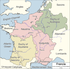
Description: The lands controlled by the Franks at the time of Charles Martel's accession in 714. Based on Paul Vidal de la Blache's Atlas général d'histoire et de géographie (1912)
Title: Francia 714
Credit: Own work based on Paul Vidal de la Blache's Atlas général d'histoire et de géographie (1912)
Author: Kairom13
Usage Terms: Creative Commons Attribution-Share Alike 4.0
License: CC BY-SA 4.0
License Link: https://creativecommons.org/licenses/by-sa/4.0
Attribution Required?: Yes
Image usage
The following 3 pages link to this image:

All content from Kiddle encyclopedia articles (including the article images and facts) can be freely used under Attribution-ShareAlike license, unless stated otherwise.