
Image: Gelderland1601-1603 Mauritius de Nassauw 1601

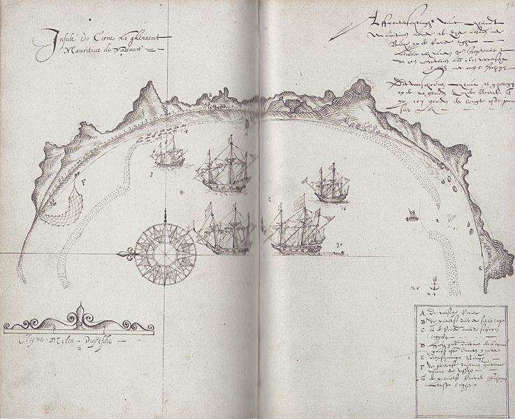
Description: Map from the journal of the Dutch ship 'Gelderland'. It shows the bay in the southwest of Mauritius. In old Dutch it says: "Insulde do Cirne nu ghenaemt Mauritius de Nassauw [=Insulde do Cirne now named Mauritius the Nassau]" and "Affconterfeytinghe vant eylant Mauritius aende w. zyde alsmen inde baye opde reede light [= Representation of the island Mauritius at the west side if you lie in the bay's roadsted], alwaer wy vanden 30en september tot den 20en octobris anno 1601 ververscht hebben met onsen 5 schepen [= where we refreshed from 30 September to 20 October 1601 with our 5 ships]. Dit voorschreven eylant is ghelegen op de 20 graden zuyder breedt ende op 107 graden der lengte ofte janner (?) seer naby [= This forementioned island is situated at a latitude of 20 degree South and at 107 degree of longitude of the Janner?? very close by]" and "A. De varsche rivier [= The fresh river], B. De plaetse daer de siecken lagen [= The place where the sick lay], C. Is de reede daer de schepen ligghen [= Is the roadstead where the ships remained], D. Het gat daermen de Kermisgansen ofte Dronten haelden [= The spot where they got the dodo's], E. Den fyninigen bergh [= The fierce mountain], F. De plaetse daermen gewoone waren te visschen [= The place where they usually fished], G. De plaetse daer de schepen eerst laghen [= The place where the ships anchored first]".
Title: Gelderland1601-1603 Mauritius de Nassauw 1601
Credit: Nationaal Archief, Den Haag, Archieven van de Compagnieën op Oost-Indië 1.04.01 inventorynumber 135
Author: Creator:Joris Joostensz Laerle
Usage Terms: Public domain
License: Public domain
Attribution Required?: No
Image usage
The following page links to this image:
