
Image: German Map Sudeten
Size of this preview: 383 × 598 pixels. Other resolutions: 153 × 240 pixels | 407 × 636 pixels.
Original image (407 × 636 pixels, file size: 103 KB, MIME type: image/png)
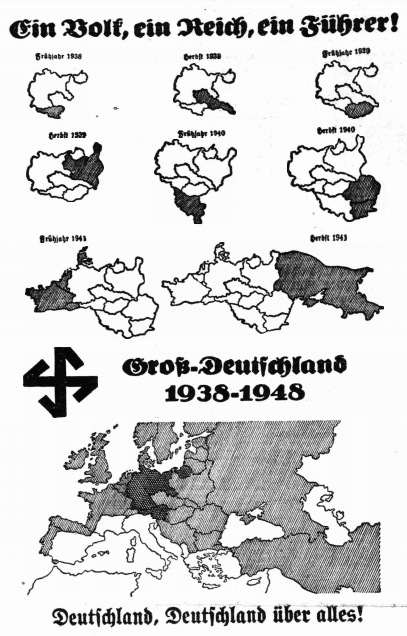
Description: Map showing Nazi German plans for a Greater Germany
Title: German Map Sudeten
Credit: From the Henlein headquarters in Beichenberg, Nazi Germany. Given to Sudeten Germans during the Sudeten Crisis "to 'encourage' or terrify 'wavering' elements". Re-published on page 2 of the British socialist newspaper the Daily Worker, under the title "Hitler's Dream of European Conquest".
Author: Government of Nazi Germany
Usage Terms: Public domain
License: Public domain
Attribution Required?: No
Image usage
The following 2 pages link to this image:

All content from Kiddle encyclopedia articles (including the article images and facts) can be freely used under Attribution-ShareAlike license, unless stated otherwise.