
Image: Global Landslide Risks
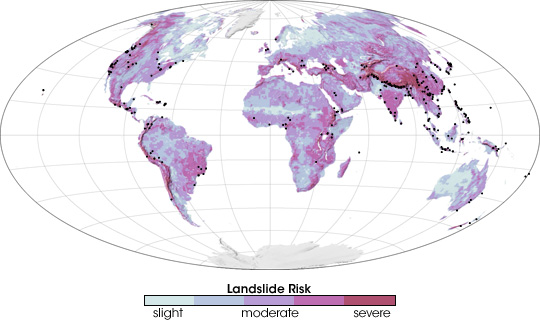
Description: Scientists are striving to reduce the loss of life from landslides by developing a global, satellite-based early-warning system. The scientists first identified landslide-prone regions, as shown in this image. To create this landslide risk map scientists mapped all of the regions that featured some combination of coarse soil, land cover that was inadequate to stabilize the surface, and/or steep mountains. The regions that have the highest risk of landslides are salmon pink. Areas of moderate risk are lavender, and regions with a slight risk are pale blue. Areas where landslides occurred between 2003 and 2006 are marked with black dots on this map.
Title: Global Landslide Risks
Credit: http://earthobservatory.nasa.gov/IOTD/view.php?id=7783
Author: Robert Simmon
Usage Terms: Public domain
License: Public domain
Attribution Required?: No
Image usage
The following page links to this image:
