
Image: Gloucester and Sharpness Canalmap

Size of this preview: 160 × 596 pixels. Other resolutions: 64 × 240 pixels | 1,504 × 5,606 pixels.
Original image (1,504 × 5,606 pixels, file size: 1.25 MB, MIME type: image/jpeg)
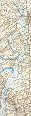
Description: Stroudwater Navigation from 1933
Title: Gloucester and Sharpness Canalmap
Credit: OS map the cotswolds 1/2 inch to the mile.
Author: OS
Usage Terms: Public domain
License: Public domain
Attribution Required?: No
Image usage
The following 2 pages link to this image:

All content from Kiddle encyclopedia articles (including the article images and facts) can be freely used under Attribution-ShareAlike license, unless stated otherwise.