
Image: Great Lakes bathymetry map

Size of this preview: 800 × 571 pixels. Other resolutions: 320 × 228 pixels | 1,024 × 731 pixels.
Original image (1,024 × 731 pixels, file size: 1.34 MB, MIME type: image/png)
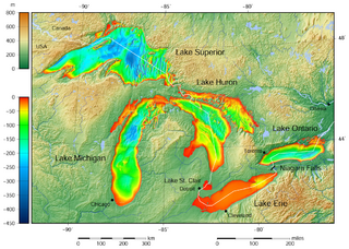
Description: Great Lakes bathymetry and surrounding area shaded relief map. Lakes are contoured with interval 100 m. Lake Superior is incomplete.
The map was created using the [1], GMT, version 5.1.1.
Author: Darekk2 using the Great Lakes Bathymetry and GLOBE tiles
Usage Terms: Creative Commons Attribution-Share Alike 3.0
License: CC-BY-SA-3.0
License Link: http://creativecommons.org/licenses/by-sa/3.0/
Attribution Required?: Yes
Image usage
The following page links to this image:

All content from Kiddle encyclopedia articles (including the article images and facts) can be freely used under Attribution-ShareAlike license, unless stated otherwise.