
Image: Greenwood, Albemarle County, Virginia Aerial USGS

Size of this preview: 750 × 600 pixels. Other resolutions: 300 × 240 pixels | 1,000 × 800 pixels.
Original image (1,000 × 800 pixels, file size: 174 KB, MIME type: image/jpeg)
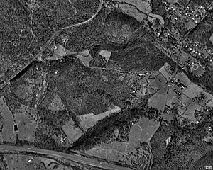
Description: Aerial photo showing the community of Greenwood, Virginia. The post office is located at the road intersection in the middle right of the photo. Interstate 64 is visible at the bottom of the photo. The railroad cut that replaced the Greenwood Tunnel is visible in the middle left of the photo.
Title: Greenwood, Albemarle County, Virginia Aerial USGS
Credit: USGS The National Map from Microsoft Research Maps.
Author: United States Geological Survey
Usage Terms: Public domain
License: Public domain
Attribution Required?: No
Image usage
The following page links to this image:

All content from Kiddle encyclopedia articles (including the article images and facts) can be freely used under Attribution-ShareAlike license, unless stated otherwise.