
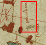
Image: Guanahani indicated in Juan de la Cosa map from 1500
No higher resolution available.
Guanahani_indicated_in_Juan_de_la_Cosa_map_from_1500.png (150 × 144 pixels, file size: 20 KB, MIME type: image/png)
Description: Guanahani (San Salvador - first string of islets discovered by Columbus in 1492) - Label and islets marked within the red box
Title: Guanahani indicated in Juan de la Cosa map from 1500
Credit: Juan de la Cosa map from 1500
Author: Juan de la Cosa
Usage Terms: Public domain
License: Public domain
Attribution Required?: No
Image usage
The following page links to this image:

All content from Kiddle encyclopedia articles (including the article images and facts) can be freely used under Attribution-ShareAlike license, unless stated otherwise.