
Guanahani facts for kids

Guanahaní was the name given by the Taíno people to an island in the Bahamas. This island was the first land in the Americas that Christopher Columbus and his crew saw and visited. This happened on October 12, 1492, during his first trip across the Atlantic Ocean.
Columbus called this bean-shaped island San Salvador. For a long time, people believed Guanahaní was the island now known as San Salvador Island (which used to be called Watlings Island). It was even officially renamed in 1925 because of this belief. However, today, experts are not so sure. They have suggested several other islands in the southern Bahamas that could also be Guanahaní.
Contents
How We Know About Guanahaní
To understand where Guanahaní might be, historians look at old documents and maps. These are called "primary sources" because they come directly from the time of Columbus.

Columbus's Own Letter
When Columbus returned to Spain in 1493, he wrote a letter to Luis de Santangel, who helped fund his trip. This letter was printed many times and translated into different languages. It was how Europe first heard about his discoveries.
In this letter, Columbus only mentions "Guanahani" as the first island he found. He doesn't give many other details. But this single mention made the name "Guanahani" famous very early on.
Map by Juan de la Cosa

Juan de la Cosa was the owner and captain of the Santa María, one of Columbus's ships. He sailed with Columbus on that first voyage. Juan de la Cosa was also a mapmaker. In 1500, he drew a world map that is famous for being the first European map to show the Americas.
The part of his map showing the Caribbean clearly shows Cuba and Hispaniola. The Bahamas part is a bit harder to understand. Still, Guanahani is drawn in the Bahamas. It looks like a group of small islands rather than just one. It's shown north of the Windward Passage, which is between Cuba and Haiti.
Columbus's Diario (Journal)
Columbus kept a logbook, or journal, during his voyages. The original journal is now lost. What we have today is a summary, or "abstract," made by Bartolomé de las Casas. He was a Spanish monk and a friend of the Columbus family. He probably made this summary around the 1540s.
When Columbus returned to Spain, he showed his original log to the King and Queen. They ordered a copy to be made. This copy, called the 'Barcelona copy,' was given back to Columbus. It was with him when he died in 1506. Later, Las Casas used this copy to create the Diario we have today.
Most of the Diario is written as if Las Casas is telling the story. But the part about Columbus's journey through the Bahamas is written in Columbus's own words. Las Casas said these were direct quotes from the 'Barcelona copy.' The Diario is the most important and detailed record of Columbus's first voyage.
Biography by Fernando Colón
In 1571, a book about Christopher Columbus was published in Italy. It was a translation of a Spanish book written by Columbus's second son, Fernando Colón, between 1537 and 1539.
Fernando likely used the 'Barcelona copy' of his father's journal when writing about the first voyage. Many details in his book match the Diario. This helps confirm that the Diario is accurate. However, Fernando's book also includes a few new details. For example, it says Guanahani was 15 leagues (about 45 miles) long. This seems to contradict Columbus's own words in the Diario, where he suggests he saw the whole island in one day by boat.
What Guanahaní Was Like
Columbus described Guanahaní as "very flat and with very green trees." This description fits many of the islands that historians think might be Guanahaní.
He also said Guanahaní had "muchas aguas y una laguna en medio muy grande" – meaning "many waters and a very big laguna in the middle." The word laguna can mean either a lagoon or a pond. Most of the suggested islands have either a lagoon or a pond.
On October 14, Columbus took a boat trip to the "eastern part" of Guanahaní. He traveled along the island in a north-northeast direction. This is only possible at a few places like Plana Cays, Conception, Egg, and a small part of Samana Cay.
Columbus also saw a reef that completely surrounded the island. Many proposed islands have reefs, but not all of them completely surround the island, like those at Cat Island and Watlings Island. Between the reef and the island, there was a harbor that Columbus said was "large enough to store all ships of Christendom." This was probably an exaggeration. The harbor at Egg Island is too small, but the nearby Royal Island has a large harbor that might have been considered part of the same area.
Columbus also went ashore and saw "a piece of land, that looked like an island, but actually wasn't one." This is hard to figure out today, as the land might have changed over the last 500 years.
Was it One Island or More?
One big question is whether Guanahani was a single island or a group of small islands. The evidence is not clear. Columbus never directly said it was more than one island. But he did say it had "another part, which is the eastern part," and he used a boat to explore it, which might mean it was separate. Also, on some copies of Juan de la Cosa's map, Guanahani looks like a chain of small islands.
Tracking Columbus's Journey
Historians try to find Guanahani by following the distances and directions Columbus wrote in his journal. This is tricky because we don't know the exact length of Columbus's "league" (a unit of distance). Also, ocean currents and how his compass worked in 1492 make it hard to be precise.
Many people have tried to retrace Columbus's path. For example, in 1986, Luis Marden of the National Geographic Society suggested Samana Cay was the most likely landing spot. In 2004, Keith Pickering used updated magnetic information and found a path that ended near the Plana Cays.
Light Before Landfall
At 10 p.m. on October 11, 1492, Columbus saw a light "like a small wax candle that rose and lifted up." He showed it to others on board; some saw it, some didn't. The actual landing spot was about 35 miles from where he saw the light. If the light came from land, it must have been from another island further east, not Guanahani itself.
- For the Plana Cays idea, the light could have been on Mayaguana.
- For Conception Island, it could have been on Cat Island, Watlings Island, or Rum Cay.
- For Caicos, it could have been on Grand Turk.
- For Cat Island, it could have been on Watlings Island.
- For Lignum Vitae Cay, it could have been Eleuthera Island.
- The Watlings, Grand Turk, and Egg Island theories don't have a clear explanation for the light.
Following the Islands After Guanahaní
Another way to find Guanahaní is to trace Columbus's path from Guanahaní to Cuba, or backward from Cuba to Guanahaní. Columbus gave many details about his courses, distances, and directions between islands. This method seems more likely to pinpoint the location.
Historians often use Roman numerals to name the islands Columbus visited to avoid confusion:
- Island I: Guanahaní
- Island II: Santa María de la Concepción
- Island III: Fernandina
- Island IV: Samoete (renamed Isabela)
After these four islands, Columbus visited a line of seven or more islands, which historians generally agree are the modern Ragged Island, Bahamas. Then he landed on the north coast of Cuba.
Island II
Columbus left Guanahaní late on October 14. He said, "I saw so many islands I did not know how to decide which one I would go to first." He aimed for the largest one, estimating it was five leagues away.
He reached Island II around noon. He said its coastline facing Guanahaní ran north–south for five leagues. Another coastline, which he followed, ran east–west for more than ten leagues.
Columbus then saw another, larger island to the west. He sailed toward it all day until night. It's not clear if he anchored at a cape on Island II or on the larger island to the west. Some historians think he visited two islands that day, calling them Island IIa and Island IIb.
Island III
Columbus left Island II for Island III on October 16. He said he sailed about eight or nine leagues (24-27 miles) to reach it. He also gave different ideas about the size of Island III, saying it "may well be" more than 28 leagues long, but later only saw "quite 20 leagues of it."
Columbus gave very detailed information about the coastline of Island III. He arrived at a cape where the coastlines ran in two directions. The next morning, he followed the coast and found a "wonderful harbor" with a small island at its entrance. He went into the harbor but found it too shallow. He then sailed northwest, seeing the rest of the island's coast. These descriptions fit very well with the southern part of Long Island.
Island IV
On October 19, Columbus split his ships to search for an island called Samoete, which his native guides had told him about. His ship, the Santa María, found the island before 9 AM. Columbus reached Island IV before noon, arriving at its northern point. He described this point as being surrounded by a reef, with a small island nearby.
Columbus's descriptions of Island IV are a bit confusing. He said Island IV was "on an east-west course" from Island III. He also said that from the northern point, the coast ran west for 12 leagues to a western cape called Cabo Hermoso. Columbus then thought Cabo Hermoso was on a separate island from Samoete.
The next morning, he tried to sail into a large bay to go around the island, but it was too shallow. He returned to the northern end of Island IV. After waiting two days for a king his guides mentioned, Columbus left Island IV at midnight on October 24. He set his course for Cuba, a large island to the south. He sailed southwest and west, and on October 25, they saw the Ragged Islands, which he called the Islas de Arena ("Sand Islands").
Possible Guanahaní Islands

Many islands have been suggested as the true Guanahaní:
- San Salvador Island (formerly Watlings Island): This island was renamed in 1925 because historians thought it was Guanahaní. It was first suggested in 1793 and is still widely accepted by many historians today. However, some argue it's not the most likely choice.
- Samana Cay: This idea was first proposed in 1880 but became more famous after a 1986 article in National Geographic Magazine.
- Plana Cays: Suggested in 1974 and again in 1994. Some argue these islands have fewer problems fitting Columbus's descriptions than other candidates.
- Grand Turk Island: Proposed in 1825, it lost favor but was brought up again in 1924.
- Cat Island: For a long time, many maps showed Cat Island as Guanahaní. But after Columbus's journal was published in the late 1800s, this idea became less popular.
- Mayaguana: Proposed in 1864.
- Conception Island: Suggested in 1943.
- East Caicos: Proposed in 1947.
- Egg Island: Suggested in 1981.
- Lignum Vitae Cay: Proposed in 1989.
Images for kids
-
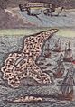
This page from Alain Manesson Mallet's five-volume world atlas shows the islet of Guanahani, the site of Columbus' first landing in 1492
-
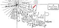
The region of the Greater Antilles in the map of de la Cosa. The red arrow points to Guanahani island. Original hand sketch by P.J.J. Valentini (1828-1899).
-
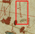
Guanahani ("San Salvador"), found by Columbus in 1492. Label and islets marked within the red box.
-
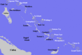
Landfall theories
See also
 In Spanish: Guanahani para niños
