
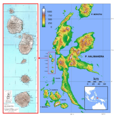
Image: Halmahera - Ternate - Tidore - Mare - Moti - Makian

Size of this preview: 583 × 599 pixels. Other resolutions: 234 × 240 pixels | 3,487 × 3,583 pixels.
Original image (3,487 × 3,583 pixels, file size: 3.47 MB, MIME type: image/png)
Description: Die Inselkette Ternate bis Makian vor der Westküste von Halmahera in den nördlichen Molukken
Title: Halmahera - Ternate - Tidore - Mare - Moti - Makian
Credit: Linke Karte: U.S. Army Map Service. - Rechte Karte: File:Halmahera topography.png (Wikimedia)
Author: Linke Karte: U.S. Army Map Service, Sheets 98/XVI, 98/XVII, 97-98/XVIII. - Rechte Karte: Sadalmelik. Zusammenstellung und Bearbeitung: Geoethno
Permission: Linke Karte: . - Rechte Karte:
Usage Terms: Public domain
License: Public domain
Attribution Required?: No
Image usage
The following page links to this image:

All content from Kiddle encyclopedia articles (including the article images and facts) can be freely used under Attribution-ShareAlike license, unless stated otherwise.