
Image: Heritage listed old bridge across Currency Creek, South Australia near Goolwa. (7771453472)
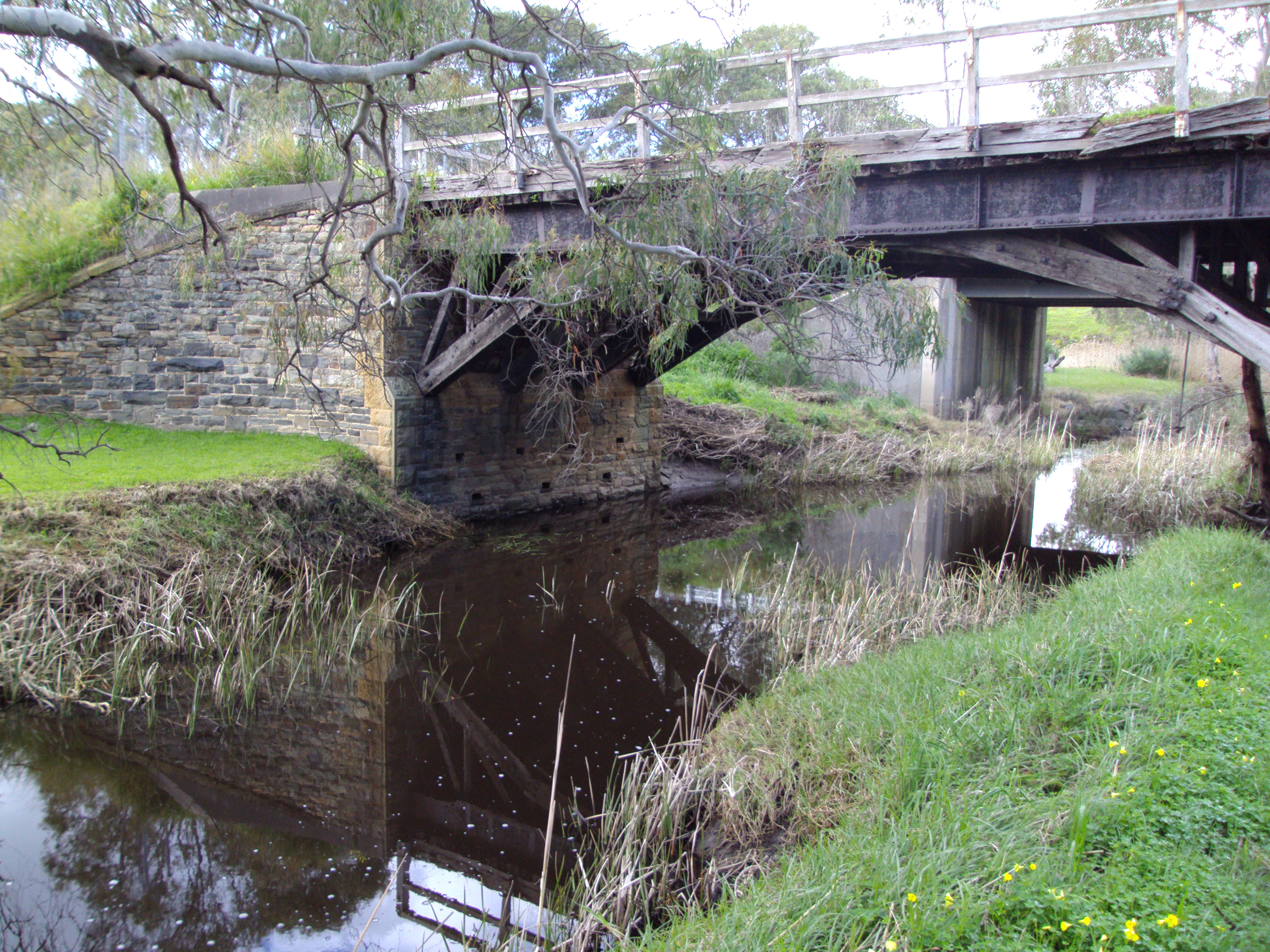
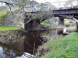
Description: The first bridge across Currency Creek in Currency Creek built in 1859. Fantastic stone work. The ugly modern bridge is behind it. Currency Creek –the New Orleans of the South. This place between the mouth of the Currency Creek and the Finniss River was one of the sites considered by William Light for the location of the capital. Adelaide plains won that decision. This area was explored in December 1837 by Mr Young Hutchison and Thomas Strangways (nephew of the later SA Premier Henry Strangways) who visited this area and named Currency Creek after Captain Blenkinsop’s ship the Currency Lass that they were exploring on. They explore Lake Alexandrina but unfortunately disaster struck and Captain Blenkinsop was drowned trying to cross the Murray mouth. Both Hutchinson and Strangways liked they area and both became large landowners in the district with Hutchinson developing part of the town of Goolwa in 1856. A short time after this exploratory voyage the Currency Creek Special Survey was taken out in 1839 by the Currency Creek Association based in England. Locally it was taken out by their agent Robert Wright on behalf of about 30 men. The Currency Creek Association laid out a major town which they hoped would become the New Orleans of the South. It was after all on a good river, near a great lake and near the mouth of the might Murray River system just like the location of New Orleans at the mouth of the Mississippi in the USA. They also laid out a much smaller port for the town which they called Goolwa. Currency Creek town covered 8 acres, Goolwa 2 acres. The Major town had three squares, including a Victoria, Albert and Gawler Square. History would show they made the wrong decision as Goolwa prospered and Currency Creek withered! A few town blocks were purchased but the first farmers did not settle the district until 1843 when some got grazing leaseholds over vast stretches of land in the nearby hills. One of the first Currency Creek town blocks sold was to Stephen Wright who bought the Currency Creek Inn site in 1842. It was sold on in 1856 and again in 1858 when the new owner, John Varco took out a large mortgage and built the two storey Georgian style Currency Creek Inn at that time. 1858 was the year of the first license for the hotel. The hotel business would have been boosted by the surveying of the Clarendon –Meadows, Ashbourne road to Currency Creek in 1859. Perhaps because of this the owner made a big profit from his £100 mortgage of 1858 for in 1860 he sold the hotel on for £500. In 1877 the Currency Creek Inn became a private residence for Thomas Sumner of a grocery store owner from Goolwa. Then in 1916 the property was sold to Mr Kingsland who renamed it Kingsview, renovated it, added 19th century verandas to “modernise” it thus destroying the original Georgian appearance. In the last 20 years it was been restored gain. This Mr Kingsland was a schemer because in 1919 he bought the Double Bridges property nearby as he had a plan for an Irrigation Scheme at the Black Swamp area of Currency Creek where the Currency Creek Winery is now situated. (This was not the first such scheme for this district. After the success of the Chaffeys at Renmark a local land owner proposed an irrigation scheme at Milang in 1892 but it never materialised.) Kingsland got the SA Parliament to pass an act allowing him to create a large dam on Currency Creek. He then purchased 1,700 acres and got options to buy a further 10,500 acres. He published a fancy prospectus in 1923 to get people to invest in his scheme and to lease options for irrigated land. He proposed 99 year leases for land suitable for dairy farmers and he would then also charge them for the water from his dam to irrigate their paddocks. He wanted to raise £250,000 in £1 shares so he sailed to England in 1923 to get investors but unfortunately his ship went down and he drowned. Nothing ever came of this grand scheme. Even before Kingsland started this bold venture in the 1920s the Black Swamp area with its good water supply and peaty rich soils was used for another purpose. The press reported in 1899 that the North Adelaide Blind School had obtained land here for growing osiers or willows for use by the blind people making baskets in the Bind School facility in Adelaide. Parts of Black Swamp are now on the Register of the National Estate as it is a perennial lake providing habitat for native sedges, plants and 150 bird species including some rare ones. Some water is taken from the lake and swamp for local irrigation. Early settlers had conflicts with the many local Aboriginal Ngarrindjeri people in the district as they grew their crops of maize, potatoes and some wheat. (A stone flour mill opened around 1860 and operated for a few years before it was converted to a timber saw mill.) Others crops were tried in the district including tobacco, fruit trees and vegetables by Chinese market gardeners in the 1880s. But the town was boosted mainly when the horse drawn tram railway came up from Goolwa and Port Elliott in 1868 as it advanced towards Strathalbyn in 1869. This required a large rail viaduct across Currency Creek but that had to be rebuilt and greatly strengthened in 1883 for the introduction of 5’3” gauge steam engines running from Adelaide to Victor Harbor. The town also had an old road bridge built in 1872 at a cost of over £1,100. By 1885 Currency Creek had a mere 13 houses, 130 residents and a few public buildings. The Wesleyan Methodist Church had been built 1869 (it closed 1943, was sold 1963 and is now in ruins); and the first town school opened in 1859- it later became a state school in 1876 before closing in 1962.( In the next century the town Institute Hall opened in 1913.) By 1885 Goolwa far exceeded Currency Creek in population and growth (it had 850 residents) and it was clear that Currency Creek would not become the New Orleans of the South. The one facility that both towns shared was the Currency Creek cemetery which opened in 1854 with its first burials in 1857.
Title: Heritage listed old bridge across Currency Creek, South Australia near Goolwa. (7771453472)
Credit: Heritage listed old bridge across Currency Creek, South Australia near Goolwa.
Author: denisbin from Adelaide, Australia
Usage Terms: Creative Commons Attribution-Share Alike 2.0
License: CC BY-SA 2.0
License Link: https://creativecommons.org/licenses/by-sa/2.0
Attribution Required?: Yes
Image usage
The following page links to this image:

.jpg)