
Image: Hobart aerial survey 1954 map05 sullivans cove
No higher resolution available.
Hobart_aerial_survey_1954_map05_sullivans_cove.png (487 × 382 pixels, file size: 419 KB, MIME type: image/png)
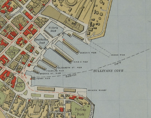
Description: Map 5 of w:Hobart aerial survey map - cropped to Sullivans Cove area
Title: Hobart aerial survey 1954 map05 sullivans cove
Credit: University of Tasmania - http://eprints.utas.edu.au/17486/
Author: Department of Lands and Surveys, Governent of Tasmania
Usage Terms: Creative Commons Zero, Public Domain Dedication
License: CC0
License Link: http://creativecommons.org/publicdomain/zero/1.0/deed.en
Attribution Required?: No
Image usage
The following 2 pages link to this image:

All content from Kiddle encyclopedia articles (including the article images and facts) can be freely used under Attribution-ShareAlike license, unless stated otherwise.