
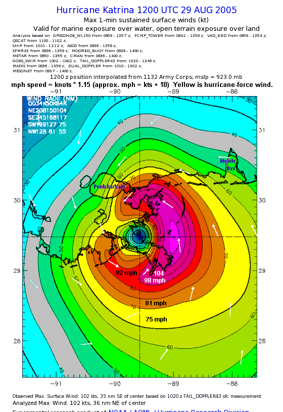
Image: Hurricane Katrina winds 1200utc29Aug05 landfall LA 1hr
Description: NOAA Hurricane Katrina windspeed map, for 29 August 2005 at 1200 UTC (7 CDT), one hour after landfall in Louisiana (at Buras-Triumph), based on post-TCR analysis data. The map has been labeled with "Pontchartrain" and "Mobile Bay" plus a top note about converting wind speed from knots/kt to mph, showing some bands also marked with "mph" and has been retouched for clarity when resized smaller.
Title: Hurricane Katrina winds 1200utc29Aug05 landfall LA 1hr
Credit: NOAA map image: ftp://ftp.aoml.noaa.gov/hrd/pub/hwind/2005/PostKatrina/0829/1200/col04deg.png (converted to GIF format +mph note).
Author: Made using NOAA map
Permission: This image is in the public domain because it contains materials that originally came from the U.S. National Oceanic and Atmospheric Administration, taken or made as part of an employee's official duties. Čeština | Deutsch | Zazaki | English | Español | Eesti | Suomi | Français | Magyar | Italiano | 日本語 | 한국어 | Македонски | മലയാളം | Plattdüütsch | Nederlands | Polski | Português | Română | Русский | Sicilianu | Slovenščina | Türkçe | 中文 | 中文(简体) | +/−
Usage Terms: Public domain
License: Public domain
Attribution Required?: No
Image usage
The following page links to this image:
