
Image: Iceland Mid-Atlantic Ridge map

Size of this PNG preview of this SVG file: 376 × 390 pixels. Other resolution: 231 × 240 pixels.
Original image (SVG file, nominally 376 × 390 pixels, file size: 129 KB)
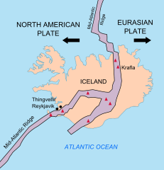
Description: Map showing the Mid-Atlantic Ridge splitting Iceland and separating the North American and Eurasian Plates. The map also shows Reykjavik, the capital of Iceland, the Thingvellir area, and the locations of some of Iceland's active volcanoes (red triangles), including Krafla.
Title: Iceland Mid-Atlantic Ridge map
Credit: http://pubs.usgs.gov/gip/dynamic/understanding.html
Author: http://pubs.usgs.gov/gip/dynamic/understanding.html
Usage Terms: Public domain
License: Public domain
Attribution Required?: No
Image usage
The following 2 pages link to this image:

All content from Kiddle encyclopedia articles (including the article images and facts) can be freely used under Attribution-ShareAlike license, unless stated otherwise.