
Image: Iron Curtain map

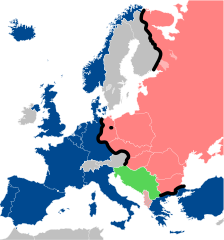
Description: Map of the Iron Curtain in Europe. NATO Warsaw Pact Albania Iron Curtain Neutral countries Non-Aligned
Title: Iron Curtain map
Credit: Travail personnel (own work). Sources: Image:Blank_map_of_Europe_cropped.svg by Revolus under licence CC-BY-SA 2.5, itfself from Image:Europe countries.svg by Júlio Reis alias Tintazul, under licence CC-BY-SA 2.5 Image:Cold war europe military alliances map.png by San Jose under licence GFDL Image:Iron Curtain Final.svg by Vernes Seferovic alias Kseferovic under licence GFDL & CC-BY-SA
Author: Sémhur
Usage Terms: Creative Commons Attribution-Share Alike 4.0
License: CC BY-SA 4.0
License Link: https://creativecommons.org/licenses/by-sa/4.0
Attribution Required?: Yes
Image usage
The following page links to this image:
