
Image: Israeli-Palestinian Railways

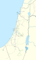
Description: This map shows all railways that have been operated by Palestine Railways, Israel Railways, or have existed on the territory of Israel/Palestine. Certain sources show more train stations at: Nevatim (31°13′0.12″N 34°52′34.48″E / 31.2167°N 34.8762444°E / 31.2167; 34.8762444), Dvir (31°24′52.94″N 34°47′38.95″E / 31.4147056°N 34.7941528°E / 31.4147056; 34.7941528), Nuseirat (31°27′26.00″N 34°24′31.12″E / 31.4572222°N 34.4086444°E / 31.4572222; 34.4086444), Zarnuqa (31°52′32.19″N 34°45′48.99″E / 31.8756083°N 34.7636083°E / 31.8756083; 34.7636083), Tirat al-Lawz (32°45′25.02″N 34°57′33.28″E / 32.75695°N 34.9592444°E / 32.75695; 34.9592444), Kabara (32°34′17.27″N 34°56′8.87″E / 32.5714639°N 34.9357972°E / 32.5714639; 34.9357972), and a few east of Haifa. I could not find a secondary source, and so they have been left out. There might also have been a Haifa-Wadi Rushmiya line. The station at Birein was probably more of a simple water refilling stop; this is possibly the same for other former stops in the Negev. The J'slm - El Bireh line was a military railway built by the British in 1918 to supply the war front North of Jerusalem. Very little information is available on it, and so its path is very hypothetical; this is also true for other lines (mostly in the Negev). Names: I tried to put former names where possible (space permitting). A plethora of translations, transliterations, and transcriptions exist when romanising Hebrew and Arabic station names. Since this map is in English, I have preferred the name that appeared the most "English" in my eyes. For clarity, a hyphen "-" is used to separate the town name from a qualifier. Borders: Undisputed borders 1949 Green line 1974 Purple line East Jerusalem municipal borders Train Lines: Open (electrified) Open Open (freight only) Being built Closed
Title: Israeli-Palestinian Railways
Credit: The background map is a merger of Israel location map.svg and Egypt location map.svg, both by NordNordWest, and also licensed under CC-BY-SA-3.0. Palestine Before The 1948 Nakbah, Dar Al Maalem, 2008. (available here: http://www.palestineremembered.com/Acre/Maps/Story11857.html). Palestine, Survey of Palestine, August 1944. (available here: http://www.palestineremembered.com/Acre/Maps/Story582.html). Palestine, British War Office, 1924. (available here: http://upload.wikimedia.org/wikipedia/commons/b/b6/Palestine_north_1924.jpg and http://upload.wikimedia.org/wikipedia/commons/b/b8/Palestine_south_1924.jpg). Map of Israel, Boris Chomenko, 2010. (available here: http://www.bueker.net/trainspotting/map.php?file=maps/israel--palestine/israel--palestine.gif). Google Maps (https://maps.google.fr/?ll=31.587894,35.606689&z=7) for the realignment of the Beersheba railway, Jaffa-Jerusalem Railway, and the Yavne-Ashdod extension. Topomapper (http://www.topomapper.com/index.html?zoom=7&lat=31.69431&lon=35.01648) for the Rafah-Kantara line (this link is now dead, but the website vlasenko.net publishes the same source material). This page (http://www.rail.co.il/EN/Stations/Pages/israelrailways-station_index.aspx) for the current passenger service. This page (http://www.rail.co.il/HE/Development/Pages/מפתתוכניתהפיתוח.aspx) for the future passenger service. Rakevethaemek_map_eng.png by en:User:Ynhockey for the location of stations along the Jezreel Valley Railway. A1 railway.png by en:User:Ynhockey for the route of the Jerusalem high-speed railway. This map (http://www.port2port.co.il/ViewImage.asp?CategoryID=336&ArticleID=71338) for the Railway to Karmiel. This page and its map (http://www.rail.co.il/HE/Development/Executed/Pages/AshqelonBeerSheva.aspx) for the Ashkelon-Beersheba railway. This map (http://en.wikipedia.org/wiki/File:רכבת_העמק.jpg) for the new Jezreel Valley Railway. This flickr album (https://www.flickr.com/photos/39631091@N03/sets/72157625896029333/with/8064048522/), which was an invaluable source for the Afula-Nablus-Eastern railway-Lod-Beersheba-Birein route. Hebrew Wikipedia articles: he:המסילה המזרחית, he:רכבת העמק, he:הקו הראשי של רכבת ישראל, he:מסילת השומרון. Pretty much anything else I could get my hands on.
Author: Mapeh
Usage Terms: Creative Commons Attribution-Share Alike 3.0
License: CC BY-SA 3.0
License Link: https://creativecommons.org/licenses/by-sa/3.0
Attribution Required?: Yes
Image usage
The following page links to this image:
