
Image: Juniperus communis North American range map 1

Size of this preview: 600 × 600 pixels. Other resolutions: 240 × 240 pixels | 8,429 × 8,429 pixels.
Original image (8,429 × 8,429 pixels, file size: 981 KB, MIME type: image/png)
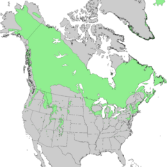
Description: The North American range map of Juniperus communis, the common juniper.
Title: Juniperus communis North American range map 1
Credit: Little, Jr., Elbert L. (1971). Digital Representations of Tree Species Range Maps. USGS Geosciences and Environmental Change Science Center. "Conifers and important hardwoods" in Atlas of United States Trees, 1, U.S. Department of Agriculture Miscellaneous Publication 1146 (9 pages, 200 maps)
Author: Elbert L. Little, Jr. of the U.S. Department of Agriculture's Forest Service
Usage Terms: Public domain
License: Public domain
Attribution Required?: No
Image usage
The following 2 pages link to this image:

All content from Kiddle encyclopedia articles (including the article images and facts) can be freely used under Attribution-ShareAlike license, unless stated otherwise.