
Image: Juniperus deppeana varieties range map 2

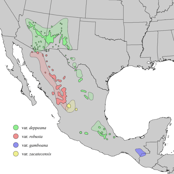
Description: Natural distribution map for Juniperus deppeana (alligator juniper). The shaded areas and indicated varieties are from Adams et al. (2006), which mapped out J. deppeana varieties and forms. The darker colors show possible varieties presented the Elbert Little (1971) map populations based only on their proximity to the shaded areas. The var. gamboana population did not appear in the Little (1971) map. It was considered to be a separate species J. gamboana until merged into J. deppeana by Adams (2006). Adams also showed var. patoniana interspersed amongst the var. robusta population, forma sperryi amongst the var. depeana populations of Arizona, New Mexico and Texas, and forma elongata also within the texas population. These were omitted from this map for simplicity.
Title: Juniperus deppeana varieties range map 2
Credit: USGS Geosciences and Environmental Change Science Center: Digital Representations of Tree Species Range Maps from: Elbert L. Little, Jr. (1971), Atlas of United States trees, Vol. 1, conifers and important hardwoods: U.S. Department of Agriculture Miscellaneous Publication 1146, 9 p., 200 maps. Additional population data and taxonomic updates from Robert P. Adams and Andrea E. Schwarzbach (2006) "Ifraspecific adjustments in Juniperus Deppeana (Cupressaceae)"; Phytologia 88(3): 227-232.
Author: Elbert L. Little, Jr., of the U.S. Department of Agriculture, Forest Service
Usage Terms: Public domain
License: Public domain
Attribution Required?: No
Image usage
The following page links to this image:
