
Image: Katrina FEMA declarations narrow
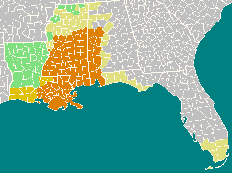
Description: This image shows FEMA disaster declarations in the aftermath of Hurricane Katrina, as a focused regional map 470x350px, with the 4 states: Florida, Alabama, Mississippi, and Louisiana. Shading: 1. the dark shade of orange represents counties eligible for full Individual and Public Assistance, 2. the intermediate shade of orange represents counties eligible for Individual and Public Assistance (Categories A and B only), 3. the light yellow-orange represents counties eligible for full Public Assistance, and 4. green represents counties eligible for Public Assistance (Category B only).
Title: Katrina FEMA declarations narrow
Credit: Image:Katrina FEMA declarations.png (Wikimedia)from FEMA disaster declarations for: Florida, Louisiana, Mississippi and Alabama.
Author: FEMA map, shaded by User:Wikid77.
Permission: This image is a work of a Federal Emergency Management Agency employee, taken or made as part of that person's official duties. As works of the U.S. federal government, all FEMA images are in the public domain in the United States. Additional media usage information may be found at https://www.fema.gov/photo-video-audio-use-guidelines čeština | English | eesti | italiano | македонски | മലയാളം | Nederlands | polski | Türkçe | українська | 中文 | 中文(简体) | 中文(繁體) | +/−
Usage Terms: Public domain
License: Public domain
Attribution Required?: No
Image usage
The following page links to this image:
