Effects of Hurricane Katrina in Mississippi facts for kids
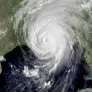
Hurricane Katrina at landfall on the Louisiana-Mississippi border
|
|
| Meteorological history | |
|---|---|
| Formed | August 29, 2005 |
| Dissipated | August 30, 2005 |
| Category 3 tropical cyclone | |
| 1-minute sustained (SSHWS/NWS) | |
| Highest winds | 120 mph (195 km/h) |
| Lowest pressure | 928 mbar (hPa); 27.40 inHg |
| Overall effects | |
| Fatalities | 238 total |
| Damage | $30 billion (2005 USD) |
| Areas affected | Mississippi, particularly the Mississippi Gulf Coast |
|
Part of the 2005 Atlantic hurricane season |
|
| Hurricane Katrina |
|
 |
|
|
General Other wikis |
|
Hurricane Katrina was a very powerful storm that hit the Mississippi coast on August 29, 2005. It brought strong winds and a huge wall of water called a storm surge. This caused a lot of damage across central Mississippi for two days. By 10 AM on August 29, the center of Katrina was moving through the state. It only slowed down from hurricane-force winds near Meridian by 7 PM, finally entering Tennessee as a tropical storm.
Many towns along the Mississippi and Louisiana coasts were destroyed in just one night. Hurricane-force winds hit coastal Mississippi around 2 AM and lasted for over 17 hours. The storm also caused 11 tornadoes in Mississippi and a 28-foot (8.5 m) storm surge. This surge flooded areas up to 12 miles (19 km) inland. Many people who couldn't leave survived by climbing into attics, onto rooftops, or swimming to higher buildings and trees. The worst damage happened in coastal Mississippi, where over 90% of towns were flooded in hours. Waves destroyed many old buildings, and others were damaged up to the third floor. In Mississippi, 238 people died. All counties in the state were declared disaster areas, with 49 getting full federal help. After the storm, rules for emergency centers and casinos were changed. Emergency centers were moved to higher ground because the old ones flooded. Casinos were allowed to be built on land instead of just on floating barges.
More than a million people in Mississippi were affected. Six months later, the damage was still described as "staggering." Over half a million people in Mississippi asked for help from FEMA. This means more than one out of every six people in the state needed help.
Contents
How Hurricanes Cause Damage
Hurricanes are large, complex storms. They can cause damage in many ways, not just from their center. They can create smaller thunderstorms, tornadoes, storm surges, and big sea waves. Winds on the east side of a hurricane's eye can be much stronger than on the west side. Wind gusts can be scattered, meaning one house might be hit hard while a nearby one is untouched. Trees can also be weakened, with branches falling months later.
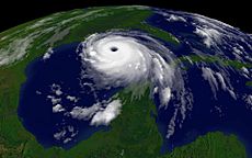
Hurricane Katrina was a huge storm, over 450 miles (724 km) wide. So, not only the eye and the 28-foot (8.5 m) storm surge caused damage. The outer parts of the hurricane also caused scattered damage hundreds of miles away. Eleven tornadoes were recorded in Mississippi. It's possible that parts of northern Mississippi were damaged by these smaller storms. This happened when Katrina first hit land near Greater New Orleans and then again near Bay St. Louis, Mississippi. When buildings collapsed, waterproof items like refrigerators floated away. These items then crashed into other buildings and blocked streets. Millions of homes, buildings, ships, boats, and over 40 offshore oil rigs were affected.
Roads and railways were blocked by huge amounts of debris. Some bridges, like the I-10 Twin Span Bridge, even collapsed. Cleaning up the debris in the Gulf Coast region cost an estimated $200 million. Until major roads like US 49 and US 59 were cleared, emergency supplies had to take long detours.
Katrina's Impact on Mississippi
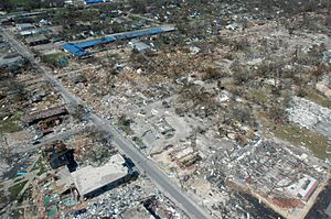
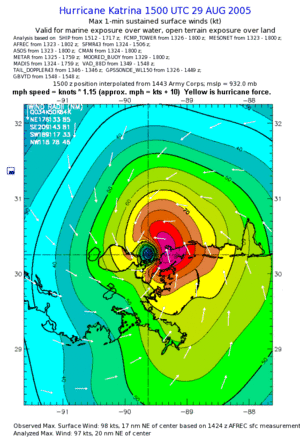
The Gulf Coast of Mississippi was almost completely destroyed by Hurricane Katrina on August 29. The storm brought hurricane winds, a 28-foot (8.5 m) storm surge, and 55-foot (16.7 m) sea waves. These waves pushed casino barges, boats, and debris into towns. This left 236 people dead, 67 missing, and billions of dollars in damage.
Katrina first hit land in Louisiana, about 30 miles (48 km) east of New Orleans. The strongest part of the storm, its right front side, covered coastal Mississippi and southern Alabama. This caused more wind and flood damage. Four hours after its first landfall, Katrina hit land again near the Mississippi state line (mouth of the Pearl River). It passed over towns like Bay St. Louis that were underwater. At this point, it was a Category 3 hurricane with winds over 120 mph (193 km/h) and a 28-foot (8.5 m) surge. Some beachfront areas were completely flattened. Flooding reached 6 to 12 miles (9.6 to 19 km) inland, even crossing Interstate-10 in some places.
Hurricane-force winds reached Hancock and Harrison County by 2 AM and kept getting stronger. By 10 AM, as Katrina hit Mississippi, hurricane-force winds affected 600,000 residents in several counties. These included Hancock, Harrison, Jackson County, Pearl River County, and others. Even cities further inland like Mendenhall, Magee, and Jackson saw strong winds (80–85 mph or 128–137 km/h). These cities had a lot of tree damage, roof damage, and power lines down. Streets in Jackson were empty due to the strong winds and rain.
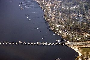
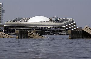
Many casinos in Mississippi were built on barges to follow gambling laws. These barges were washed hundreds of yards inland by the waves. News reports said a 28-foot (8.5 m) storm surge wiped out 90% of buildings along the Biloxi-Gulfport coastline. Many streets and bridges were washed away, including parts of the U.S. Highway 90 bridge between Bay St. Louis and Pass Christian. Only the support structures were left.
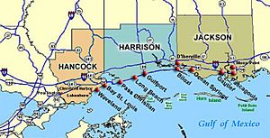
The three counties hit hardest were Hancock County, Harrison County, and Jackson County. However, almost all counties had some damage, and 47 were declared full disaster areas. About 800,000 people across the state lost power, which is almost a third of Mississippi's population.
The three coastal counties had about 400,000 people. Most of them had left before Katrina flooded the 100-mile (160 km) region. Katrina's storm surge was the biggest and highest ever recorded in the U.S. Large parts of Hancock, Harrison, and Jackson counties were covered by the storm surge. This affected most of the populated areas. The surge covered almost the entire lower half of Hancock County, destroying towns like Clermont Harbor and Waveland. It also flooded much of Bay St. Louis and flowed up the Jourdan River, flooding Kiln.
In Harrison County, Pass Christian was completely flooded, along with a narrow strip of land to the east. This included Long Beach and Gulfport. Flooding was even worse in places like D'Iberville, which is next to the Back Bay of Biloxi. Biloxi, located on a peninsula, was hit especially hard, particularly the low-lying Point Cadet area.
In Jackson County, the storm surge flowed up the wide river estuary. The combined surge and freshwater floods cut the county in half. Over 90% of Pascagoula, the easternmost coastal city, was flooded by the surge. Other Jackson County towns like Porteaux Bay were destroyed. St. Martin, Ocean Springs, Moss Point, Gautier, and Escatawpa also suffered major surge damage.
Two destroyer ships being built at Litton-Ingalls Shipbuilding in Pascagoula were damaged. The Amphibious assault ship USS Makin Island was also damaged.
The day after Katrina, Mississippi Governor Haley Barbour said the scene was "indescribable." He compared it to what Hiroshima might have looked like 60 years earlier. The mayor of Biloxi called it "our tsunami." Early relief efforts focused on getting power back and clearing debris, which was up to 8 feet (2.4 m) deep.
Many historic buildings in Mississippi were destroyed. This included cottages and porches around the Beauvoir mansion, which was the home of Jefferson Davis. Hundreds of priceless items from the Civil War era were lost or destroyed. The lower three floors of many tall casino-hotels were also ruined.
Emotional Impact
Both the people in Mississippi who survived Hurricane Katrina and the disaster relief workers who helped them faced a high risk of developing PTSD. This is a mental health condition that can happen after someone experiences a very stressful event, like a natural disaster.
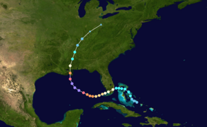
Hurricane Katrina's Journey
Hurricane Katrina started as a Category 1 hurricane on August 25. It crossed the southern tip of Florida, dropping 14 inches (36 cm) of rain. Then it moved into the Gulf, where it first weakened, then grew into a huge Category 5 storm with 175 mph (280 km/h) winds. It slowly turned north along the eastern coast of Louisiana. By 4 AM on August 29, its winds were 132 mph (212 km/h), 90 miles (145 km) southeast of New Orleans.
Katrina hit land near Buras, LA at 6:10 AM CDT, with reported 125 mph (201 km/h) winds (Category 3). It passed 40 miles (64 km) east of New Orleans and headed towards the Mississippi state line (mouth of the Pearl River) by 10 AM CDT. Hurricane-force winds continued through central Mississippi until they weakened near Meridian. The storm then entered Tennessee as a tropical storm. Even though the hurricane's strongest winds were centered on Mississippi, nearby areas were also affected. New Orleans began to flood slowly. A 28-foot (8.5 m) storm surge eastward from Bay St. Louis destroyed coastal areas with 30-55 foot (9-16.7 m) sea waves. This flooding went 12 miles (19 km) inland. The waves pushed barges, oil rigs, ships, and debris into flooded towns, flattening many coastal buildings all the way to Pascagoula with a 20-foot (6 m) surge. It also affected Alabama with a 15-foot (4.5 m) surge and 24-foot (7.3 m) waves hitting beach houses inside Mobile Bay.
Mississippi Evacuation Efforts
By 4:30 AM CDT on August 29, 2005, just hours before Hurricane Katrina hit land, many shelters in Mississippi were full. This included Red Cross shelters, the Jackson Coliseum (which allowed pets), and special-needs shelters. These shelters had filled up within 24 hours of opening.
Days earlier, on August 25, when Katrina crossed Florida, Mississippi government offices had already discussed emergency evacuation plans. On August 26, the Mississippi National Guard was called into action. On August 27, the state government opened its Emergency Operations Center, and local governments started ordering evacuations. The Mississippi Emergency Management Agency (MEMA) advised against opening shelters in coastal counties. However, on August 28, the Red Cross did open shelters in coastal counties. By 7:00 PM, 11 counties and 11 cities had issued evacuation orders. This number grew to 41 counties and 61 cities before Katrina hit the next morning. Also, 57 emergency shelters were set up in coastal communities, with 31 more ready if needed.
Since not everyone evacuated, many people survived the 30-foot (9 m) storm tide by climbing into their second-floor attics. Some even broke through walls and ceilings to get onto their roofs or nearby trees. Tree trunks remained standing, even near the beaches where many houses were destroyed. Other people swam to taller buildings or trees. Over 100 people were rescued from rooftops and trees in Mississippi. Even though the three coastal counties had almost 400,000 people, and the storm tide was 20-30 feet (6-9 m) with coastal winds of 75–120 mph (120–193 km/h), fewer than 250 people died in Mississippi during Hurricane Katrina.
Federal Aid for Rebuilding
The U.S. Federal Government planned to rebuild or fix its projects in Mississippi. The cost to get these federal buildings back to normal operations was significant:
- Over $1.9 billion was requested by President George W. Bush for Navy Shipbuilding and Conversion. These funds helped Northrop Grumman replace damaged equipment and prepare naval vessels. Ships in Pascagoula were damaged.
- Increased funding was given for USDA housing programs, which offer loans and repair money for homes.
- $75 million was set aside for wildlife habitat restoration. This was for the Corps of Engineers to improve river habitats in Mississippi, like oyster reefs and coastal marshes.
- Another $75 million went to the Corps of Engineers for various coastal projects to finish authorized work along the Mississippi Gulf Coast faster.
- $1.1 billion was allocated to repair important federal facilities in Mississippi, including:
* $292.5 million for the VA hospital in Biloxi. * $45 million for the Armed Forces Retirement Home in Gulfport. * $277.2 million for the United States Navy to rebuild the Seabee base in Gulfport and the Stennis Space Center. * $43.4 million to rebuild Keesler Air Force Base. * $45 million for the Keesler Medical Center. * $82.8 million for new Navy housing in the Gulfport/Stennis area. * $324.8 million for housing at Keesler Air Force Base. * $48.9 million for Navy housing at the Naval Air Station Meridian and the Seabee base in Gulfport.
These costs were for work continuing in 2006. The repairs included modern updates, not just restoring buildings to their original state. These amounts show the huge construction damage, not even counting all the smaller damages like lost roof tiles or broken windows.
Impact on Specific Counties
Hancock County
Hancock County was where the eye of Hurricane Katrina made its final landfall. This caused complete destruction in Waveland, Bay St. Louis, Pearlington, and Clermont Harbor. The bridge connecting Bay St. Louis and Pass Christian was destroyed.
Katrina's 28-foot (8.5 m) storm surge and 55-foot (16.7 m) sea waves almost completely wiped out Waveland, Mississippi. State officials said it was hit harder by wind and water than any other town on the coast. The storm hit during high tide, making the surge even higher, over 30 feet (9 m). The storm washed away almost every building within half a mile of the beach, leaving only driveways and walkways that led to nothing. About 50 people died there.
In Bay St. Louis, Mississippi, one foot (30 cm) of water flooded the Emergency Operations Center at the Hancock County courthouse, even though it was 30 feet (9 m) above sea level. Katrina also destroyed the first floor and dorms of Saint Stanislaus College. About a quarter of the local workers lost their jobs, and the unemployment rate reached 24.3%.
Harrison County
Harrison County, Mississippi was severely hit by the hurricane and storm surge. Its two largest coastal cities, Biloxi and Gulfport, suffered huge damage and many deaths. By September, 126 people were confirmed dead. Smaller coastal towns were also badly damaged. Much of Long Beach and most of Pass Christian were leveled.
In Biloxi, a tourist town, many attractions were destroyed. The lower three floors of many tall casino-hotels were ruined, like the former Grand Casino in Gulfport, or the Imperial Palace and Beau Rivage in Biloxi. Many restaurants were destroyed, and several casino barges were washed out of the water and onto land. People who had survived Hurricane Camille in 1969 said Katrina was "much worse." Katrina's storm surge reportedly went further inland than Camille's. Keesler Air Force Base in Biloxi also had extensive damage. Gulfport officials reported that up to ten feet of water covered downtown streets. The Biloxi-Ocean Springs Bridge was completely destroyed, and US 90 had heavy debris and severe road damage.
Thirty of the confirmed deaths in Harrison County were at the St. Charles apartment complex. This complex reportedly collapsed with many residents inside. Rebuilding in Harrison County happened at different speeds. Biloxi was helped a lot by the return of the casino industry. Smaller towns like Pass Christian did not have a strong economy to help with rebuilding. By January 2007, almost a year and a half after the hurricane, Pass Christian had not yet started rebuilding its city buildings, and volunteers were still helping rebuild private homes.
The ECHL Mississippi Sea Wolves, a hockey team in Biloxi, had to stop playing for two years because the Mississippi Coast Coliseum was damaged. The team started playing again in 2007.
Jackson County
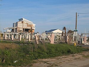
In Jackson County, the storm surge flowed up the wide river estuary. The combined surge and freshwater floods cut the county in half. Over 90% of Pascagoula, the easternmost coastal city in Mississippi, was flooded by the surge. Pascagoula is 75 miles (120 km) east of where Katrina hit land. Other Jackson County communities like Porteaux Bay and Gulf Hills were destroyed. St. Martin was hit hard, along with Ocean Springs, Moss Point, Gautier, and Escatawpa.
United States Navy officials announced that two Arleigh Burke-class guided missile destroyers being built at Litton-Ingalls Shipbuilding in Pascagoula were damaged by the storm. The amphibious assault ship USS Makin Island was also damaged.
Counties Affected by Katrina
After Hurricane Katrina, all counties in Mississippi were declared disaster areas. 49 counties were able to get full Federal assistance. The following Mississippi counties reported deaths, tornadoes, or damage:
- Adams County: 2 deaths.
- Forrest County: 7 deaths.
- Hancock County: 51 deaths.
- Harrison County: 126 deaths.
- Hinds County: 1 death.
- Jackson County: 12 deaths, and 2 tornadoes.
- Jasper County: 1 tornado.
- Jones County: 12 deaths.
- Kemper County: 1 tornado.
- Lamar County: 1 tornado.
- Lauderdale County: 2 deaths, and 1 tornado.
- Leake County: 1 death, and 3 tornadoes.
- Lowndes County: 1 tornado.
- Neshoba County: 2 tornadoes.
- Oktibbeha County: 1 tornado.
- Pearl River County: 17 deaths.
- Scott County: 1 tornado.
- Simpson County: 1 death.
- Stone County: 1 death.
- Warren County: 1 death.
- Winston County: 1 tornado.
The 49 counties in Mississippi that received full Federal assistance were: Adams, Amite, Attala, Claiborne, Choctaw, Clarke, Copiah, Covington, Franklin, Forrest, George, Greene, Hancock, Harrison, Hinds, Holmes, Humphreys, Jackson, Jasper, Jefferson, Jefferson Davis, Jones, Kemper, Lamar, Lauderdale, Lawrence, Leake, Lincoln, Lowndes, Madison, Marion, Neshoba, Newton, Noxubee, Oktibbeha, Pearl River, Perry, Pike, Rankin, Scott, Simpson, Smith, Stone, Walthall, Warren, Wayne, Wilkinson, Winston and Yazoo.
Regional Impact
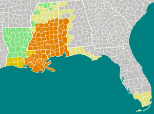
Since Hurricane Katrina traveled through the entire state, Mississippi was at the center of the disaster area for the region. Outside the areas of high winds and storm surge, other places were affected by tornadoes and heavy rainfall. The map below shows the declared disaster areas in the region.
The southern tip of Florida also had damage when Hurricane Katrina first formed in the Caribbean Sea. It dumped over 14 inches (36 cm) of rain in that area.
Long-Term Effects
Rebuilding towns took many years, and some areas were never fully restored. The bay bridges were rebuilt taller and stronger. Because all three Emergency Command Centers in Mississippi's coastal counties had flooded, rules for command center locations were changed. They now had to be built on even higher ground. Casino gambling rules were also changed. Casinos were allowed to be built on land in taller buildings. This prevented the problem of huge floating casino barges becoming battering rams during storms. Many local water systems were destroyed. The state government decided to rebuild them as a few larger regional water systems and one big regional sewage system.
People began to understand the massive destruction along the Gulf Coast cities. The US Army Corps of Engineers made plans to rebuild the protective barrier islands that had been washed away. Detailed reports described how people survived by swimming to taller buildings or trees. Sadly, those who were too old or couldn't swim did not survive. Many residents moved away and never returned. Studies tried to estimate how many indirect deaths were caused by people losing their homes or local medical support.
 | Frances Mary Albrier |
 | Whitney Young |
 | Muhammad Ali |


