Kemper County, Mississippi facts for kids
Quick facts for kids
Kemper County
|
|
|---|---|

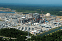
The Kemper Project power plant
|
|

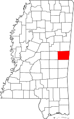
Location within the U.S. state of Mississippi
|
|
 Mississippi's location within the U.S. |
|
| Country | |
| State | |
| Founded | 1833 |
| Named for | Reuben Kemper |
| Seat | De Kalb |
| Largest Town | De Kalb |
| Area | |
| • Total | 767 sq mi (1,990 km2) |
| • Land | 766 sq mi (1,980 km2) |
| • Water | 0.8 sq mi (2 km2) 0.1% |
| Population
(2020)
|
|
| • Total | 8,988 |
| • Density | 11.718/sq mi (4.524/km2) |
| Time zone | UTC−6 (Central) |
| • Summer (DST) | UTC−5 (CDT) |
| Congressional district | 3rd |
Kemper County is a county located in the eastern part of Mississippi, a state in the United States. In 2020, about 8,988 people lived there. The main town and county seat is De Kalb. The county is named after Reuben Kemper.
Kemper County is part of the Meridian area. A big power plant project called the Kemper Project was approved in 2010. It was designed to make electricity using a special "clean coal" method. This project aimed to be a model for using new technologies to capture carbon from coal.
East Mississippi Community College is also located in Kemper County, in the town of Scooba. It's easy to find at the meeting point of US 45 and Mississippi Highway 16.
Contents
History of Kemper County
In the 1800s, white farmers developed the land in Kemper County to grow cotton. The county is still mostly rural today. After the American Civil War, there were difficult times. Many formerly enslaved people, known as freedmen, lived in the county. In 1890, more than half of the people living in Kemper County were Black.
In 1934, a very important court case happened that involved Kemper County. Some African-American suspects were forced to confess to a crime. The U.S. Supreme Court later ruled in a case called Brown v. Mississippi (1936) that confessions made under force cannot be used in court. This ruling helped protect people's rights.
The county's population was highest in 1930. Over time, new machines made farming easier, so fewer people were needed for farm work. From 1940 to 1970, many people moved away to find jobs in other places. This was part of a big movement called the Great Migration, where millions of African Americans moved from the Southern states to the North and West.
Geography of Kemper County
Kemper County covers about 767 square miles. Most of this area, about 766 square miles, is land. Only a small part, about 0.8 square miles, is water.
Major roads in Kemper County
Neighboring counties
- Noxubee County (to the north)
- Sumter County, Alabama (to the east)
- Lauderdale County (to the south)
- Neshoba County (to the west)
- Winston County (to the northwest)
People in Kemper County
| Historical population | |||
|---|---|---|---|
| Census | Pop. | %± | |
| 1840 | 7,663 | — | |
| 1850 | 12,517 | 63.3% | |
| 1860 | 11,682 | −6.7% | |
| 1870 | 12,920 | 10.6% | |
| 1880 | 15,719 | 21.7% | |
| 1890 | 17,961 | 14.3% | |
| 1900 | 20,492 | 14.1% | |
| 1910 | 20,348 | −0.7% | |
| 1920 | 19,619 | −3.6% | |
| 1930 | 21,881 | 11.5% | |
| 1940 | 21,867 | −0.1% | |
| 1950 | 15,893 | −27.3% | |
| 1960 | 12,277 | −22.8% | |
| 1970 | 10,233 | −16.6% | |
| 1980 | 10,148 | −0.8% | |
| 1990 | 10,356 | 2.0% | |
| 2000 | 10,453 | 0.9% | |
| 2010 | 10,456 | 0.0% | |
| 2020 | 8,988 | −14.0% | |
| 2023 (est.) | 8,584 | −17.9% | |
| U.S. Decennial Census 1790-1960 1900-1990 1990-2000 2010-2013 |
|||
What the 2020 census shows
In 2020, the United States Census counted 8,988 people living in Kemper County. There were 3,611 households and 2,201 families.
| Race | Num. | Perc. |
|---|---|---|
| White | 2,812 | 31.29% |
| Black or African American | 5,486 | 61.04% |
| Native American | 460 | 5.12% |
| Asian | 6 | 0.07% |
| Pacific Islander | 1 | 0.01% |
| Other/Mixed | 156 | 1.74% |
| Hispanic or Latino | 67 | 0.75% |
What the 2010 census showed
In 2010, there were 10,456 people in the county. About 60% were Black or African American, and about 35% were White. There were also Native American, Asian, and people of two or more races. A small number were Hispanic or Latino.
Education in Kemper County
Public schools
- Kemper County School District
Kemper County is served by the East Mississippi Community College system. The main campus and offices for the college are in Scooba.
Kemper Project: Electric Power Plant
In 2010, the state approved building a power plant in Kemper County. This plant was designed to use lignite coal to make electricity for many counties in southeastern Mississippi. It was planned as a special project to show how new technologies could be used to turn coal into gas and capture carbon pollution.
The project faced some challenges. It was supposed to open in 2016, but it was delayed. The cost also grew much higher than first expected. By February 2017, the cost had reached about $7.1 billion.
Communities in Kemper County
Towns
Census-designated place
- Bogue Chitto (Part of this community is also in Neshoba County.)
Unincorporated communities
These are smaller communities that are not officially organized as towns.
- Electric Mills
- Kellis Store
- Minden
- Moscow
- Preston
- Porterville
- Union Hill
- Wahalak
Ghost town
- Binnsville (A ghost town is a place where most or all people have left.)
Notable people from Kemper County
- Eddie Briggs, who was the 28th Lieutenant Governor of Mississippi.
- Bud Brown, a former professional football player, born in DeKalb.
- Clay Hopper, a professional baseball player.
- Sampson Jackson, who served in the Mississippi State Senate, born in Preston.
- John J. Pettus, the 23rd Governor of Mississippi.
- Devonta Pollard, a professional basketball player.
- J.H. Rush, who started the first private hospital in Meridian.
- John C. Stennis, who was a United States Senator for a very long time (from 1947 to 1988), born in Kemper County.
See also
 In Spanish: Condado de Kemper para niños
 | Precious Adams |
 | Lauren Anderson |
 | Janet Collins |

