Simpson County, Mississippi facts for kids
Quick facts for kids
Simpson County
|
|
|---|---|

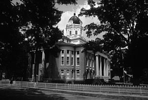
Simpson County courthouse in Mendenhall
|
|

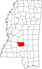
Location within the U.S. state of Mississippi
|
|
 Mississippi's location within the U.S. |
|
| Country | |
| State | |
| Founded | 1824 |
| Named for | Josiah Simpson |
| Seat | Mendenhall |
| Largest city | Magee |
| Area | |
| • Total | 590 sq mi (1,500 km2) |
| • Land | 589 sq mi (1,530 km2) |
| • Water | 1.3 sq mi (3 km2) 0.2% |
| Population
(2020)
|
|
| • Total | 25,949 |
| • Estimate
(2023)
|
25,715 |
| • Density | 44.0/sq mi (16.98/km2) |
| Time zone | UTC−6 (Central) |
| • Summer (DST) | UTC−5 (CDT) |
| Congressional district | 3rd |
Simpson County is a special area in the state of Mississippi, USA. It's like a big neighborhood with its own local government. The western edge of the county is along the Pearl River. This river was very important for travel and trade a long time ago.
In 2020, about 25,949 people lived in Simpson County. The main town where the county government is located is called Mendenhall. The county is named after Josiah Simpson, who was a judge and helped create Mississippi's first constitution. Simpson County is also part of the larger Jackson area, which is a big group of cities and towns connected together.
Contents
About Simpson County's Land
Simpson County covers a total area of about 590 square miles. Most of this area is land, about 589 square miles. A small part, about 1.3 square miles, is water.
Main Roads in Simpson County
These are the most important roads that help people travel through Simpson County:
- U.S. Highway 49
- Mississippi Highway 13
- Mississippi Highway 28
- Mississippi Highway 43
- Mississippi Highway 149
Neighboring Counties
Simpson County shares its borders with several other counties:
- Rankin County (to the north)
- Smith County (to the east)
- Covington County (to the southeast)
- Jefferson Davis County (to the south)
- Lawrence County (to the southwest)
- Copiah County (to the west)
People of Simpson County
| Historical population | |||
|---|---|---|---|
| Census | Pop. | %± | |
| 1830 | 2,680 | — | |
| 1840 | 3,380 | 26.1% | |
| 1850 | 4,734 | 40.1% | |
| 1860 | 6,080 | 28.4% | |
| 1870 | 5,718 | −6.0% | |
| 1880 | 8,008 | 40.0% | |
| 1890 | 10,138 | 26.6% | |
| 1900 | 12,800 | 26.3% | |
| 1910 | 17,201 | 34.4% | |
| 1920 | 18,109 | 5.3% | |
| 1930 | 20,897 | 15.4% | |
| 1940 | 22,024 | 5.4% | |
| 1950 | 21,819 | −0.9% | |
| 1960 | 20,454 | −6.3% | |
| 1970 | 19,947 | −2.5% | |
| 1980 | 23,441 | 17.5% | |
| 1990 | 23,953 | 2.2% | |
| 2000 | 27,639 | 15.4% | |
| 2010 | 27,503 | −0.5% | |
| 2020 | 25,949 | −5.7% | |
| 2023 (est.) | 25,715 | −6.5% | |
| U.S. Decennial Census 1790-1960 1900-1990 1990-2000 2010-2013 |
|||
The population of Simpson County has changed over many years. In 2020, there were 25,949 people living here. These people lived in about 9,486 homes, and 6,617 of these were families.
Towns and Communities
Simpson County has several towns and communities where people live.
Cities
Town
Village
Other Communities
These are smaller places in the county that are not officially cities, towns, or villages:
Old Towns
- Westville was once a town, but now it's a "ghost town," meaning most people have moved away.
Learning and Education
The Simpson County School District is in charge of the public schools in the area. Students in Simpson County can also attend Copiah–Lincoln Community College. This college has been serving the county since 1934 and has a special center right in Simpson County.
Images for kids
See also
 In Spanish: Condado de Simpson (Misisipi) para niños
 | Jackie Robinson |
 | Jack Johnson |
 | Althea Gibson |
 | Arthur Ashe |
 | Muhammad Ali |


