Lawrence County, Mississippi facts for kids
Quick facts for kids
Lawrence County
|
|
|---|---|

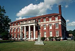
Lawrence County Courthouse
|
|

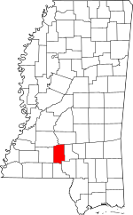
Location within the U.S. state of Mississippi
|
|
 Mississippi's location within the U.S. |
|
| Country | |
| State | |
| Founded | 1814 |
| Named for | James Lawrence |
| Seat | Monticello |
| Largest town | Monticello |
| Area | |
| • Total | 436 sq mi (1,130 km2) |
| • Land | 431 sq mi (1,120 km2) |
| • Water | 5.1 sq mi (13 km2) 1.2% |
| Population
(2020)
|
|
| • Total | 12,016 |
| • Density | 27.56/sq mi (10.641/km2) |
| Time zone | UTC−6 (Central) |
| • Summer (DST) | UTC−5 (CDT) |
| Congressional district | 3rd |
Lawrence County is a place in the state of Mississippi, United States. It's like a big neighborhood or district. In 2020, about 12,016 people lived here. The main town and center of the county is Monticello. The county is named after a brave naval hero called James Lawrence.
Contents
Exploring Lawrence County
Where is Lawrence County?
Lawrence County covers an area of about 436 square miles. Most of this area is land, around 431 square miles. The rest, about 5.1 square miles, is water.
Main Roads
You can travel through Lawrence County using these important roads:
Neighboring Counties
Lawrence County shares its borders with several other counties:
- Simpson County to the northeast
- Jefferson Davis County to the east
- Marion County to the southeast
- Walthall County to the south
- Lincoln County to the west
- Copiah County to the northwest
People of Lawrence County
Population Changes Over Time
The number of people living in Lawrence County has changed a lot over the years. Here's how the population has grown and shrunk:
| Historical population | |||
|---|---|---|---|
| Census | Pop. | %± | |
| 1820 | 4,916 | — | |
| 1830 | 5,293 | 7.7% | |
| 1840 | 5,920 | 11.8% | |
| 1850 | 6,478 | 9.4% | |
| 1860 | 9,213 | 42.2% | |
| 1870 | 6,720 | −27.1% | |
| 1880 | 9,420 | 40.2% | |
| 1890 | 12,318 | 30.8% | |
| 1900 | 15,103 | 22.6% | |
| 1910 | 13,080 | −13.4% | |
| 1920 | 12,663 | −3.2% | |
| 1930 | 12,471 | −1.5% | |
| 1940 | 13,983 | 12.1% | |
| 1950 | 12,639 | −9.6% | |
| 1960 | 10,215 | −19.2% | |
| 1970 | 11,137 | 9.0% | |
| 1980 | 12,518 | 12.4% | |
| 1990 | 12,458 | −0.5% | |
| 2000 | 13,258 | 6.4% | |
| 2010 | 12,929 | −2.5% | |
| 2020 | 12,016 | −7.1% | |
| 2023 (est.) | 11,741 | −9.2% | |
| U.S. Decennial Census 1790-1960 1900-1990 1990-2000 2010-2013 |
|||
Who Lives Here?
In 2020, there were 12,016 people living in Lawrence County. These people lived in 4,849 households, which are like family units or groups of people living together. There were also 3,385 families.
Here's a look at the different groups of people living in Lawrence County as of 2020:
| Race | Num. | Perc. |
|---|---|---|
| White (non-Hispanic) | 7,807 | 64.97% |
| Black or African American (non-Hispanic) | 3,690 | 30.71% |
| Native American | 17 | 0.14% |
| Asian | 33 | 0.27% |
| Pacific Islander | 4 | 0.03% |
| Other/Mixed | 258 | 2.15% |
| Hispanic or Latino | 207 | 1.72% |
Towns and Communities
Towns
Lawrence County has a few official towns:
- Monticello (This is the county seat!)
- New Hebron
- Silver Creek
Other Communities
There are also smaller communities that are not officially towns:
- Arm
- Jayess
- Oak Vale (partly in Jefferson Davis County)
- Sontag
- Topeka
Learning in Lawrence County
All the public schools in Lawrence County are managed by the Lawrence County School District. This district covers the entire county.
For students who want to continue their education after high school, Lawrence County is part of the Copiah–Lincoln Community College district. It has been since 1965.
Famous People from Lawrence County
- Earl W. Bascom (1906-1995): He was a famous rodeo champion, an artist who drew cowboys, and an inventor. He's even in the Mississippi Rodeo Hall of Fame! People called him the "Father of Modern Rodeo" and "Father of Mississippi Rodeo."
- Edgar Godbold (1872-1952): He was a school principal in Lawrence County from 1905 to 1906. Later, he became president of two colleges.
- Rod Paige: He was born and grew up in Lawrence County. He became the Secretary of Education for the United States from 2001 to 2004, working for President George W. Bush.
See also
 In Spanish: Condado de Lawrence (Misisipi) para niños
 | Charles R. Drew |
 | Benjamin Banneker |
 | Jane C. Wright |
 | Roger Arliner Young |

