
Rankin County, Mississippi facts for kids
Quick facts for kids
Rankin County
|
|
|---|---|

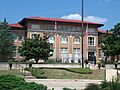
Rankin County Courthouse in Brandon
|
|

Location within the U.S. state of Mississippi
|
|
 Mississippi's location within the U.S. |
|
| Country | |
| State | |
| Founded | February 4, 1828 |
| Named for | Christopher Rankin |
| Seat | Brandon |
| Largest city | Pearl |
| Area | |
| • Total | 806 sq mi (2,090 km2) |
| • Land | 775 sq mi (2,010 km2) |
| • Water | 31 sq mi (80 km2) 3.8% |
| Population
(2020)
|
|
| • Total | 157,031 |
| • Density | 194.83/sq mi (75.22/km2) |
| Time zone | UTC−6 (Central) |
| • Summer (DST) | UTC−5 (CDT) |
| Congressional district | 3rd |
Welcome to Rankin County! This special area is a county located in the state of Mississippi in the United States. Imagine a map: the western edge of Rankin County follows the winding path of the Pearl River.
In 2020, about 157,031 people lived here. This makes Rankin County the fourth-largest county in Mississippi by population. The main town, or county seat, where the county government is located, is Brandon.
Rankin County got its name from Christopher Rankin. He was an important person who served in the U.S. Congress for Mississippi from 1819 to 1826. Rankin County is also part of the larger Jackson Metropolitan Area. This means it's connected to the big city of Jackson.
Contents
Exploring Rankin County's Geography
Rankin County covers a total area of about 806 square miles. Most of this is land, around 775 square miles. The rest, about 31 square miles, is water. That's about 3.8% of the total area!
Neighboring Counties: Who Are Rankin County's Neighbors?
Rankin County shares its borders with several other counties. Think of them as its neighbors:
- Madison County is to the north.
- Scott County is to the east.
- Smith County is to the southeast.
- Simpson County is to the south.
- Hinds County is to the west.
People and Population: Who Lives in Rankin County?
Over the years, more and more people have chosen to live in Rankin County. Here's how the population has grown:
| Historical population | |||
|---|---|---|---|
| Census | Pop. | %± | |
| 1830 | 2,083 | — | |
| 1840 | 4,631 | 122.3% | |
| 1850 | 7,227 | 56.1% | |
| 1860 | 13,635 | 88.7% | |
| 1870 | 12,977 | −4.8% | |
| 1880 | 16,752 | 29.1% | |
| 1890 | 17,922 | 7.0% | |
| 1900 | 20,955 | 16.9% | |
| 1910 | 23,944 | 14.3% | |
| 1920 | 20,272 | −15.3% | |
| 1930 | 20,353 | 0.4% | |
| 1940 | 27,934 | 37.2% | |
| 1950 | 28,881 | 3.4% | |
| 1960 | 34,322 | 18.8% | |
| 1970 | 43,933 | 28.0% | |
| 1980 | 69,427 | 58.0% | |
| 1990 | 87,161 | 25.5% | |
| 2000 | 115,327 | 32.3% | |
| 2010 | 141,617 | 22.8% | |
| 2020 | 157,031 | 10.9% | |
| 2023 (est.) | 160,417 | 13.3% | |
| U.S. Decennial Census 1790-1960 1900-1990 1990-2000 2010-2019 |
|||
Understanding the Community: A Look at Diversity
In 2020, there were 157,031 people living in Rankin County. These people made up 57,011 households and 39,676 families. The county is home to a mix of different backgrounds, making it a diverse place to live.
| Race | Num. | Perc. |
|---|---|---|
| White (non-Hispanic) | 111,990 | 71.32% |
| Black or African American (non-Hispanic) | 32,430 | 20.65% |
| Native American | 255 | 0.16% |
| Asian | 2,260 | 1.44% |
| Pacific Islander | 94 | 0.06% |
| Other/Mixed | 4,935 | 3.14% |
| Hispanic or Latino | 5,067 | 3.23% |
Getting Around: Transportation in Rankin County
It's easy to travel in and out of Rankin County thanks to its many roads and an airport.
Major Roads: Connecting Communities
Many important roads, called highways, run through Rankin County. They help people travel to different towns and cities.
 Interstate 20
 Interstate 55
 U.S. Highway 80
 U.S. Highway 49
 Mississippi Highway 13
 Mississippi Highway 18
 Mississippi Highway 25
 Mississippi Highway 43
 Mississippi Highway 149
 Mississippi Highway 468
 Mississippi Highway 469
 Mississippi Highway 471
 Mississippi Highway 475
 Mississippi Highway 477
 Mississippi Highway 481
Flying High: The Local Airport
If you need to fly, the Jackson Evers International Airport is right here in Rankin County. It's not part of any specific city, but it's a big part of the county.
Communities: Towns and Cities in Rankin County
Rankin County is home to many different communities, from bustling cities to quiet villages.
Cities in Rankin County
- Brandon (This is the county seat!)
- Florence
- Flowood
- Jackson (Most of Jackson is in Hinds County, but a small part is in Rankin and Madison Counties too!)
- Pearl
- Richland
Towns in Rankin County
Villages in Rankin County
Census-Designated Places
These are areas that are like towns but don't have their own local government.
Other Unincorporated Communities
These are smaller places that are not officially part of a city, town, or village.
- Anse
- Cross Roads
- Fannin
- Goshen Springs
- Greenfield
- Gulde
- Johns
- Langford
- Leesburg
- Piney Woods
- Pisgah
- Sand Hill
- Star
- Whitfield
- Woodlake
Former Communities
These places used to be communities but are no longer recognized as such.
Learning and Education: Schools in Rankin County
Rankin County has excellent schools for students of all ages.
Public School Districts
There are two main public school districts here:
- Pearl Public School District: This district serves students living within the city of Pearl.
- Rankin County School District: This district covers all other areas of Rankin County.
Private Schools
For those who prefer private education, there are several options:
- Hartfield Academy in Flowood
- Jackson Preparatory School in Flowood
- Park Place Christian Academy in Pearl
- East Rankin Academy in Pelahatchie
Higher Education: College Opportunities
After high school, students in Rankin County can attend Hinds Community College. The college has a campus right in Pearl, making it easy for local students to continue their education.
Images for kids
-
Rankin County Courthouse in Brandon
See also
 In Spanish: Condado de Rankin para niños
