Pelahatchie, Mississippi facts for kids
Quick facts for kids
Pelahatchie, Mississippi
|
|||
|---|---|---|---|
|
|||

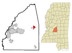
Location of Pelahatchie, Mississippi
|
|||
| Country | United States | ||
| State | Mississippi | ||
| County | Rankin | ||
| Government | |||
| • Type | Mayor-Council | ||
| Area | |||
| • Total | 6.08 sq mi (15.74 km2) | ||
| • Land | 5.94 sq mi (15.39 km2) | ||
| • Water | 0.14 sq mi (0.35 km2) | ||
| Elevation | 358 ft (109 m) | ||
| Population
(2020)
|
|||
| • Total | 1,272 | ||
| • Density | 214.11/sq mi (82.67/km2) | ||
| Time zone | UTC-6 (Central (CST)) | ||
| • Summer (DST) | UTC-5 (CDT) | ||
| ZIP code |
39145
|
||
| Area code(s) | 601 & 769 | ||
| FIPS code | 28-56200 | ||
| GNIS feature ID | 0675578 | ||
Pelahatchie is a small town located in Rankin County, Mississippi, in the United States. In 2010, about 1,334 people lived there. It is part of the larger Jackson, Mississippi area. The town's zip code is 39145.
Contents
History of Pelahatchie
Pelahatchie was started in 1850. Its name comes from the nearby Pelahatchie Creek. The word "Pelahatchie" means "crooked creek" in a Native American language.
Early Development and Railroads
In the late 1800s, Pelahatchie became an important place in the county. This was mostly because it had access to the railroad. The railroad ran right through the middle of town, helping it grow.
Schools in Pelahatchie
The town is home to two schools. One is a public school called Pelahatchie Attendance Center. Its sports teams are known as the Chiefs. The other is a private school called East Rankin Academy, whose teams are called the Patriots.
Recent Mayors of Pelahatchie
In June 2017, Ryshonda Harper Beechem was elected as mayor. She was the first African-American mayor in all of Rankin County. In June 2021, Karl VanHorn won the election and became the new mayor.
Geography of Pelahatchie
Pelahatchie covers a total area of about 3.2 square miles (8.3 square kilometers). All of this area is land. The town is located in a central part of Mississippi.
Population and People
Understanding the population helps us learn about the town's growth. The numbers below show how many people have lived in Pelahatchie over many years.
| Historical population | |||
|---|---|---|---|
| Census | Pop. | %± | |
| 1880 | 117 | — | |
| 1890 | 139 | 18.8% | |
| 1900 | 326 | 134.5% | |
| 1910 | 943 | 189.3% | |
| 1920 | 1,212 | 28.5% | |
| 1930 | 1,599 | 31.9% | |
| 1940 | 938 | −41.3% | |
| 1950 | 867 | −7.6% | |
| 1960 | 1,066 | 23.0% | |
| 1970 | 1,306 | 22.5% | |
| 1980 | 1,445 | 10.6% | |
| 1990 | 1,553 | 7.5% | |
| 2000 | 1,461 | −5.9% | |
| 2010 | 1,334 | −8.7% | |
| 2020 | 1,272 | −4.6% | |
| U.S. Decennial Census | |||
Pelahatchie's Population in 2020
The 2020 United States census counted 1,272 people living in Pelahatchie. These people lived in 613 households, with 489 of them being families.
| Race | Num. | Perc. |
|---|---|---|
| White (non-Hispanic) | 772 | 60.69% |
| Black or African American (non-Hispanic) | 409 | 32.15% |
| Asian | 6 | 0.47% |
| Other/Mixed | 40 | 3.14% |
| Hispanic or Latino | 45 | 3.54% |
Education in Pelahatchie
The Rankin County School District is in charge of the public schools in Pelahatchie.
Public Schools in Town
- Pelahatchie Elementary School teaches students from kindergarten to 6th grade.
- Pelahatchie Attendance Center is for older students, from 7th to 12th grade.
Private Schools in Town
- East Rankin Academy is a private school option for families in the area.
See also
 In Spanish: Pelahatchie para niños
 | Bayard Rustin |
 | Jeannette Carter |
 | Jeremiah A. Brown |


