
Scott County, Mississippi facts for kids
Quick facts for kids
Scott County
|
|
|---|---|

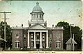
1900 Scott County Courthouse (replaced 1924 and again in 1955)
|
|

Location within the U.S. state of Mississippi
|
|
 Mississippi's location within the U.S. |
|
| Country | |
| State | |
| Founded | 1833 |
| Named for | Abram M. Scott |
| Seat | Forest |
| Largest city | Forest |
| Area | |
| • Total | 610 sq mi (1,600 km2) |
| • Land | 609 sq mi (1,580 km2) |
| • Water | 1.2 sq mi (3 km2) 0.2% |
| Population
(2020)
|
|
| • Total | 27,990 |
| • Estimate
(2023)
|
27,507 |
| • Density | 45.9/sq mi (17.72/km2) |
| Time zone | UTC−6 (Central) |
| • Summer (DST) | UTC−5 (CDT) |
| Congressional district | 3rd |
Scott County is a county located in the state of Mississippi in the United States. In 2020, about 27,990 people lived there. The main city and county seat (where the county government is) is Forest. The county is named after Abram M. Scott, who was the Governor of Mississippi from 1832 to 1833.
Contents
Exploring Scott County's Geography
Scott County covers a total area of about 610 square miles. Most of this area, 609 square miles, is land. Only a small part, about 1.2 square miles, is water.
The county is located about a 45-minute drive from Jackson, a larger city in Mississippi.
Main Roads in Scott County
These are the important highways that run through Scott County:
 Interstate 20
 U.S. Highway 80
 Mississippi Highway 13
 Mississippi Highway 21
 Mississippi Highway 35
Neighboring Counties
Scott County shares borders with several other counties:
- Leake County (to the north)
- Newton County (to the east)
- Smith County (to the south)
- Rankin County (to the west)
- Madison County (to the northwest)
Protected Natural Areas
Part of the Bienville National Forest is located within Scott County. This is a large area of protected forest land.
Scott County's Past: A Look at History
The area that is now Scott County was first developed by European Americans. They created large farms called cotton plantations. After the American Civil War, many formerly enslaved people, known as freedmen, worked on these farms. They often shared crops or rented land.
In 1890, the state government made new laws. These laws made it very hard for most Black people to vote. Black people were the majority in Mississippi at that time. The state also passed Jim Crow laws, which treated Black people as second-class citizens.
During the late 1800s and early 1900s, there were sad and unfair events in Scott County. These included acts of violence against Black people. One difficult event happened in October 1898 in Harperville. There was a conflict when Black residents resisted an arrest. This led to violence and the deaths of several Black men. Newspapers across the country reported on these events.
Understanding Scott County's Population
| Historical population | |||
|---|---|---|---|
| Census | Pop. | %± | |
| 1840 | 1,653 | — | |
| 1850 | 3,961 | 139.6% | |
| 1860 | 8,139 | 105.5% | |
| 1870 | 7,847 | −3.6% | |
| 1880 | 10,845 | 38.2% | |
| 1890 | 11,740 | 8.3% | |
| 1900 | 14,316 | 21.9% | |
| 1910 | 16,723 | 16.8% | |
| 1920 | 16,420 | −1.8% | |
| 1930 | 20,914 | 27.4% | |
| 1940 | 23,144 | 10.7% | |
| 1950 | 21,681 | −6.3% | |
| 1960 | 21,187 | −2.3% | |
| 1970 | 21,369 | 0.9% | |
| 1980 | 24,556 | 14.9% | |
| 1990 | 24,137 | −1.7% | |
| 2000 | 28,423 | 17.8% | |
| 2010 | 28,264 | −0.6% | |
| 2020 | 27,990 | −1.0% | |
| 2023 (est.) | 27,507 | −2.7% | |
| U.S. Decennial Census 1790-1960 1900-1990 1990-2000 2010-2013 |
|||
Population in 2020
In 2020, there were 27,990 people living in Scott County. These people lived in 10,180 households, and 7,015 of these were families.
Here's a look at the different groups of people in Scott County in 2020:
| Race | Number of People | Percentage |
|---|---|---|
| White | 13,145 | 46.96% |
| Black or African American | 9,923 | 35.45% |
| Native American | 95 | 0.34% |
| Asian | 103 | 0.37% |
| Other/Mixed | 576 | 2.06% |
| Hispanic or Latino | 4,148 | 14.82% |
Population in 2010
In 2010, Scott County had 28,264 people. There were 10,248 households and 7,264 families. The county had about 46 people living per square mile.
About 36% of households had children under 18 living with them. About 50% were married couples. About 26% were not families.
The average age of people in the county was 34 years old. About 28.6% of the population was under 18. About 12.4% were 65 years or older.
The average income for a household was $26,686. For families, it was $31,487. About 20.7% of all people in the county lived below the poverty line. This included 26.8% of those under 18.
Local News and Media
The Scott County Times is a local newspaper that has served Scott County since 1939. It is published once a week and is owned by Emmerich Newspapers, Inc.
Communities in Scott County
Scott County has several towns and cities:
Cities
Towns
- Lake (partly in Newton County)
- Sebastopol (partly in Leake County)
Census-Designated Places
These are areas that are like towns but are not officially incorporated as cities or towns:
Other Small Communities
Education in Scott County
Children in Scott County attend schools in these districts:
- Forest Municipal School District
- Scott County School District
Images for kids
-
1900 Scott County Courthouse (replaced 1924 and again in 1955)
See also
 In Spanish: Condado de Scott (Misisipi) para niños
