
Image: KentTestonBridge0629

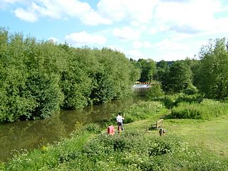
Description: A view up river from mediaeval Teston Bridge, to Teston Lock and Weir, on the River Medway, in Kent, 10.4km above Allington. We see the Teston Bridge Picnic Site on the west bank with fisherman. Public Day Fishing Tickets available. At the The water falls from +7.31m to +5.41m above mean sea level. Built in 1911, on site of locks dating from 1740s. These locks take craft upto 24.5m x 5.6m,the weir in centre picture, was older used in conjunction with the Tutsham watermill on the south bank ,now decayed and not visible. Camera location 51° 15′ 05.04″ N, 0° 26′ 48.12″ E View this and other nearby images on: OpenStreetMap - Google Earth 51.251400; 0.446700
Title: KentTestonBridge0629
Credit: Own work
Author: Clem Rutter, Rochester, Kent.
Usage Terms: Creative Commons Attribution 2.5
License: CC BY 2.5
License Link: http://creativecommons.org/licenses/by/2.5
Attribution Required?: Yes
Image usage
The following page links to this image:
