
Image: Kilimanjaro from space 2016
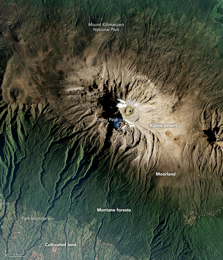
Description: Stories about Mount Kilimanjaro often focus on its height and location. The mountain—the tallest in Africa—is capped with snow and ice, despite sitting at a tropical latitude close to the equator. This volcanic mountain in Tanzania also has been in the news lately because that snowcap is shrinking, and scientists have gone to great lengths to understand why. Viewed from a wide, top-down view, Kilimanjaro becomes compelling for a different reason: To get to the icy summit, you must pass through incredibly diverse vegetation zones. Those zones are visible in this natural-color image, acquired on January 20, 2017, by the Advanced Land Imager (ALI) on NASA’s Earth Observing-1 satellite. The mountain rises 5200 meters (17,000 feet) from the hot, dry savanna, through rainforest and hardy scrublands, to a rocky and icy summit at 5895 meters (19,340 feet) above sea level. People have cultivated the lowlands ringing the mountain, which appear as patchy green areas in the bottom-left corner of this image. There is little natural vegetation on the foothills. Instead, people have taken advantage of the volcano’s rich soil to grow maize and beans, and to establish home gardens and coffee farms. The continuous dark-green band around the mountain is forest, which stretches from roughly 1800 to 2800 meters in altitude. Ground-based researchers have found distinct ecosystems and forest types within this green band, but from space, we mostly see it as the lower boundary of Kilimanjaro National Park. When the park was established in 1973, only small corridors within the forest belt were protected. In 2005, the park boundaries were redrawn to include the more of the montane forests. As we move up Kilimanjaro, the dark green areas transition to a band of green-brown known as the moorland zone. Vegetation still survives here, but it is nothing like the wet, humid forests found at lower elevations. The climate is colder and less humid, and the landscape is full of shorter, hardier plants such as the mountain’s iconic senecios and lobelias. The moorland landscape extends to about 4000 meters, above which vegetation becomes even more scarce. The highest alpine desert and summit zones are relatively inhospitable. But climbers who make the journey are rewarded with an expansive view. References and Further Reading see original
Title: Kilimanjaro from space 2016
Credit: http://earthobservatory.nasa.gov/IOTD/view.php?id=89605&src=eoa-iotd
Author: NASA Earth Observatory image by Jesse Allen
Permission: This file is in the public domain in the United States because it was solely created by NASA. NASA copyright policy states that "NASA material is not protected by copyright unless noted". (See Template:PD-USGov, NASA copyright policy page or JPL Image Use Policy.) Warnings: Use of NASA logos, insignia and emblems is restricted per U.S. law 14 CFR 1221. The NASA website hosts a large number of images from the Soviet/Russian space agency, and other non-American space agencies. These are not necessarily in the public domain. Materials based on Hubble Space Telescope data may be copyrighted if they are not explicitly produced by the STScI.[1] See also Template:PD-Hubble and Template:Cc-Hubble. The SOHO (ESA & NASA) joint project implies that all materials created by its probe are copyrighted and require permission for commercial non-educational use. [2] Images featured on the Astronomy Picture of the Day (APOD) web site may be copyrighted. [3] The National Space Science Data Center (NSSDC) site has been known to host copyrighted content even though its photo gallery FAQ states that all of the images in the photo gallery are in the public domain.
Usage Terms: Public domain
License: Public domain
Attribution Required?: No
Image usage
The following page links to this image:
