
Image: King George Island map-en

Size of this PNG preview of this SVG file: 661 × 403 pixels. Other resolution: 320 × 195 pixels.
Original image (SVG file, nominally 661 × 403 pixels, file size: 209 KB)
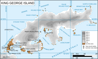
Description: King George Island map. Detailed. Relief. Research Stations.
Title: King George Island map-en
Credit: Kgeorge_map.png Ile_du_roi-George_(carte-fr).svg
Author: Kgeorge_map.png: Giovanni Fattori Ile_du_roi-George_(carte-fr).svg: *Kgeorge_map.png: Giovanni Fattori derivative work: Trex (talk) derivative work: Treehill (fr) Treehill
Usage Terms: Creative Commons Attribution-Share Alike 3.0
License: CC BY-SA 3.0
License Link: https://creativecommons.org/licenses/by-sa/3.0
Attribution Required?: Yes
Image usage
The following 2 pages link to this image:

All content from Kiddle encyclopedia articles (including the article images and facts) can be freely used under Attribution-ShareAlike license, unless stated otherwise.