Penguin Island (South Shetland Islands) facts for kids

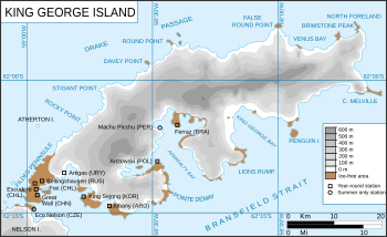
King George Island
|
|
|
Location of Penguin Island
|
|
| Geography | |
|---|---|
| Location | Antarctica |
| Coordinates | 62°06′00″S 57°55′41″W / 62.10000°S 57.92806°W |
| Length | 1.7 km (1.06 mi) |
| Width | 1.4 km (0.87 mi) |
| Highest elevation | 180 m (590 ft) |
| Highest point | Deacon Peak |
| Administration | |
| Administered under the Antarctic Treaty System | |
| Demographics | |
| Population | Uninhabited |
| Penguin Island | |
|---|---|
| Highest point | |
| Elevation | 180 m (590 ft) |
| Geography | |
| Location | Antarctica |
| Topo map | USGS |
| Geology | |
| Mountain type | Stratovolcano |
| Last eruption | 1905 (?) |
Penguin Island is a small, special island located in Antarctica. It's part of the South Shetland Islands group. This island is also known by other names like Georges Island and Isla Pingüino.
Contents
How Penguin Island Got Its Name
Penguin Island was first seen in January 1820. A British team led by Edward Bransfield discovered it. He named the island "Penguin Island" because of the many penguins living on its shores. It was a perfect name for a place so full of these amazing birds!
Exploring Penguin Island
This island is quite small, about 1.4 km (0.87 mi) wide and 1.7 km (1.1 mi) long. It's special because it doesn't have ice covering it, unlike many places in Antarctica. Penguin Island is shaped like an oval.
It sits very close to the south coast of a much bigger island called King George Island. Penguin Island helps mark the entrance to King George Bay.
The island has low cliffs along its edges. But don't worry, there's a beach on the north side that makes it easy to get onto the island. You can also find a small lake in the northeast part of the island.
The highest point on Penguin Island is a hill called Deacon Peak. This peak is actually an old volcano cone made of a rock called basaltic scoria. Scientists think Deacon Peak last erupted about 300 years ago. There's also another volcanic spot called Petrel Crater on the east side. It's believed to have erupted around 1905.
The Volcano Underneath
Penguin Island is actually the very top part of a large underwater volcano! This volcano is called a stratovolcano, which is a cone-shaped volcano built up by many layers of hardened lava and ash. It's part of an area known as the Bransfield Basin.
The base of this volcano is huge, about 8 kilometers (5 miles) across. Its total height from the seafloor is about 350 meters (1,150 feet). Penguin Island is just the top third of this giant.
The main crater of the volcano is about 150 meters (490 feet) deep. You can even see two small, black volcanic plugs inside the red cinder cone crater. This volcano is connected to the movement of Earth's plates in the Shetland area, which causes volcanic activity.
A Special Place for Wildlife
Penguin Island is super important for many birds and seals. BirdLife International has named it an Important Bird Area (IBA). This means it's a vital spot for different kinds of seabirds to live and raise their young.
One of the most important groups of birds here is a large breeding colony of over 600 pairs of southern giant petrels. Imagine seeing that many!
Other birds that nest on Penguin Island include Adélie and chinstrap penguins. You can also spot Antarctic terns and kelp gulls flying around.
It's not just birds! Weddell seals and southern elephant seals also love to visit the island. They often come ashore to rest, a behavior called "hauling out." It's a busy and lively place for Antarctic wildlife!
See also
 In Spanish: Isla Pingüino (Antártida) para niños
 | George Robert Carruthers |
 | Patricia Bath |
 | Jan Ernst Matzeliger |
 | Alexander Miles |


