
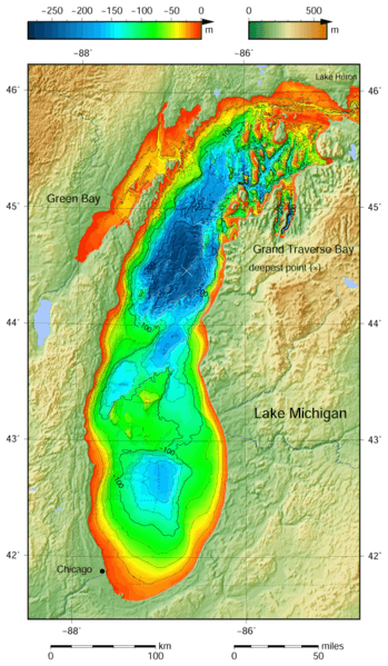
Image: Lake Michigan bathymetry map

Description: Lake Michigan bathymetric shaded relief map contoured with interval 25 m (100 m with thicker lines). The deepest point is marked with "×". For land the vertical datum is sea level, for bathymetry low water datum of the lake. The map was created using the Generic Mapping Tools, GMT, version 5.1.1.
Title: Lake Michigan bathymetry map
Credit: Own work using: the following Public Domain datasets (grids): Great Lakes Bathymetry from National Geophysical Data Center http://www.ngdc.noaa.gov/mgg/greatlakes/greatlakes.html. Credits: National Geophysical Data Center, 1996. Bathymetry of Lake Michigan. National Geophysical Data Center, NOAA. doi:10.7289/V5B85627 [access date: 2015-03-23]. National Geophysical Data Center, 1999. Bathymetry of Lake Huron. National Geophysical Data Center, NOAA. doi:10.7289/V5G15XS5 [access date: 2015-03-23]. (only small portion of this map) GLOBE http://www.ngdc.noaa.gov/mgg/topo/gltiles.html - land part of this map. Credits: National Geophysical Data Center, 1999. Global Land One-kilometer Base Elevation (GLOBE) v.1. Hastings, D. and P.K. Dunbar. National Geophysical Data Center, NOAA. doi:10.7289/V52R3PMS [access date: 2015-03-16]. The coordinates of deepest point are taken from the NOAA Great LakesEnvironmental Research Laboratory webpage (www.glerl.noaa.gov/, kml file Google Earth Great Lakes Tour). The color palette of the depth scale was made to be more or less similar to the color palettes used on the NGDC Lake Michigan maps. Created with Generic Mapping Tools (GMT)
Author: Darekk2 using the Great Lakes Bathymetry and GLOBE tiles
Usage Terms: Creative Commons Attribution-Share Alike 4.0
License: CC BY-SA 4.0
License Link: http://creativecommons.org/licenses/by-sa/4.0
Attribution Required?: Yes
Image usage
The following page links to this image:
