
Image: Lake Powell surface area shrinkage

Size of this PNG preview of this SVG file: 512 × 543 pixels. Other resolution: 226 × 240 pixels.
Original image (SVG file, nominally 512 × 543 pixels, file size: 213 KB)
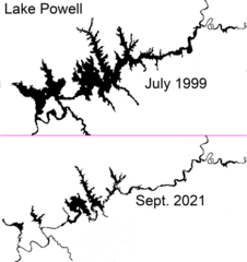
Description: Lake Powell surface area shrinkage from 1999 to 2021 from Landsat imagery, showing the effect of the protracted drought on the amount of water impounded by the Glen Canyon Dam.
Title: Lake Powell surface area shrinkage
Credit: Own work
Author: Nwbeeson
Usage Terms: Creative Commons Attribution-Share Alike 4.0
License: CC BY-SA 4.0
License Link: https://creativecommons.org/licenses/by-sa/4.0
Attribution Required?: Yes
Image usage
The following page links to this image:

All content from Kiddle encyclopedia articles (including the article images and facts) can be freely used under Attribution-ShareAlike license, unless stated otherwise.