
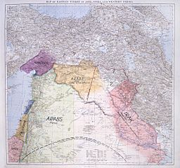
Image: Lawrence of Arabia's map, presented to the Eastern Committee of the War Cabinet in November 1918

Size of this preview: 639 × 600 pixels. Other resolutions: 256 × 240 pixels | 2,048 × 1,923 pixels.
Original image (2,048 × 1,923 pixels, file size: 1.01 MB, MIME type: image/jpeg)
Description: Lawrence of Arabia's map, presented to the Eastern Committee of the War Cabinet in November 1918. From the British National Archives
Title: Lawrence of Arabia's map, presented to the Eastern Committee of the War Cabinet in November 1918
Credit: British National Archives
Author: T. E. Lawrence
Usage Terms: Public domain
License: Public domain
Attribution Required?: No
Image usage
The following 3 pages link to this image:

All content from Kiddle encyclopedia articles (including the article images and facts) can be freely used under Attribution-ShareAlike license, unless stated otherwise.