
Image: LocationKingdomAraucania

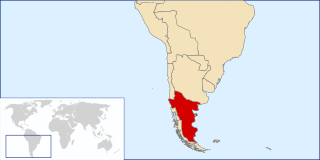
Description: Locator map of the Kingdom of Araucania and Patagonia (approx. 1860-1862). The map shows only an idea of the territory disputed by the unrecognized Kingdom because there isn't any exact definition of it. Also the historical frontiers of other countries aren't accurate. The zone of Aysen, Magallanes and Tierra del Fuego islands are shown as a separate entity because it was disputed by Chile and Argentina at the time. Most of Western Patagonia (also disputed by both countries) are shown as a territory of the Kingdom.
Title: LocationKingdomAraucania
Credit: self-made based in Image:LocationChile.svg and Image:Continents.svg
Author: B1mbo
Usage Terms: Creative Commons Attribution-Share Alike 4.0
License: CC BY-SA 4.0
License Link: https://creativecommons.org/licenses/by-sa/4.0
Attribution Required?: Yes
Image usage
The following page links to this image:
