
Image: Location map Anvers Island Antarctica

Size of this preview: 778 × 600 pixels. Other resolutions: 312 × 240 pixels | 2,878 × 2,218 pixels.
Original image (2,878 × 2,218 pixels, file size: 2.48 MB, MIME type: image/png)
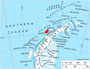
Description: Location map, for Anvers Island in the Palmer Archipelago, Antarctic Peninsula, Antarctica. Map centered near 65°00′S 64°00′W.
Title: Location map Anvers Island Antarctica
Credit: https://commons.wikimedia.org/wiki/File:Ant-pen_map.png
Author: Giovanni Fattori
Permission: GNU free documentation
Usage Terms: GNU Free Documentation License
License: GFDL
License Link: http://www.gnu.org/copyleft/fdl.html
Attribution Required?: Yes
Image usage
The following page links to this image:

All content from Kiddle encyclopedia articles (including the article images and facts) can be freely used under Attribution-ShareAlike license, unless stated otherwise.