
Anvers Island facts for kids

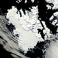
NASA image of Anvers Island
|
|

Anvers
Location in Antarctica
Location in Antarctica
|
|
| Geography | |
|---|---|
| Location | Antarctica |
| Coordinates | 64°33′S 63°35′W / 64.550°S 63.583°W |
| Archipelago | Palmer Archipelago |
| Area | 2,432 km2 (939 sq mi) |
| Length | 61 km (37.9 mi) |
| Highest elevation | 2,760 m (9,060 ft) |
| Highest point | Mount Français |
| Administration | |
| Administered under the Antarctic Treaty System | |
| Demographics | |
| Population | ~50 |
.svg)

Anvers Island is a large, mountainous island in Antarctica. It is the biggest island in the Palmer Archipelago. The island is about 61 kilometers (38 miles) long.
It was discovered by John Biscoe in 1832. In 1898, the Belgian Antarctic Expedition officially named it. They named it after the province of Antwerp in Belgium. Anvers Island is located southwest of Brabant Island. Part of its southwestern coast is a special protected area. This area is called the Southwest Anvers Island and Palmer Basin. A small island named Cormorant Island, which is important for birds, is also nearby.
Palmer Station
Palmer Station is located on Anvers Island. It is the only U.S. station in Antarctica that is north of the Antarctic Circle. The station was finished in 1968. About 50 people can live and work at Palmer Station at one time.
The station is named after Nathaniel Palmer. He was likely one of the first three people to see Antarctica. Palmer Station has science labs where scientists study the area. It also has a dock for ships.
Old British Station
The British Antarctic Survey once had a station on Anvers Island. This station was called Base N. It was used for surveying and studying geology. The station was open from February 1955 to January 1958.
In 1958, the British station closed. Its main building was later loaned to the U.S. Government in 1963. American scientists used it as a lab for their work at the nearby Palmer Station. The British station was also used to support an air facility from 1969 to 1971. Sadly, it was destroyed by fire in December 1971. This happened while it was being fixed up.
The remains of the station were removed in 1990 and 1991. Today, only the concrete foundations are left. A special runway for planes, called a skiway, was used from 1969 to 1973. Air operations moved to another station in 1973. The skiway was still used sometimes until 1993.
Ships in Trouble
On February 11, 1972, a ship called the Lindblad Explorer got stuck near La Plaza Point. It was later pulled free and taken for repairs.
Another ship, the ARA Bahía Paraíso, sank near Palmer Station and Anvers Island. This happened on January 28, 1989.
D'Abnour Bay
D'Abnour Bay is a small bay on Anvers Island. It is about 3 nautical miles (5.6 kilometers) east-southeast of Cape Gronland. The bay was first mapped by the French Antarctic Expedition (1903–05).
The expedition was led by J.B. Charcot. He named the bay after a French naval officer, Contre-amiral Richard d'Abnour.
Images for kids
-
NASA image of Anvers Island
See also
 In Spanish: Isla Anvers para niños
