
Antwerp (province) facts for kids
Quick facts for kids Antwerp (Dutch: Antwerpen; French: Anvers) |
|||
| Province of Belgium | |||
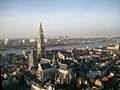
 Antwerp riverfront
|
|||
|
|||
| Country | |||
|---|---|---|---|
| Region | |||
| Capital | Antwerp | ||
| - coordinates | 51°13′N 04°24′E / 51.217°N 4.400°E | ||
| Highest point | Beerzelberg | ||
| - location | Putte, Mechelen, Antwerp | ||
| - elevation | 51.6 m (169 ft) | ||
| Area | 2,867 km² (1,107 sq mi) | ||
| Population | 1,836,030 (1 January 2017) | ||
| Density | 640 /km² (1,658 /sq mi) | ||
| Subdivisions | 3 Arrondissements 70 Municipalities |
||
| Governor | Cathy Berx | ||
| Timezone | CET (UTC+1) | ||
| - summer (DST) | CEST (UTC+2) | ||
| Postal codes | 2000–2999 | ||
| ISO 3166-2 | BE-VAN | ||

.svg)
Antwerp (in Dutch: Antwerpen, in French: Anvers) is the northernmost province in Belgium. It is part of the Flemish Region, also known as Flanders.
The city of Antwerp is the biggest city in the province. It is also the province's capital. The important Port of Antwerp is located in this city.
Contents
History of Antwerp Province
The area that is now the province of Antwerp was once called the Deux-Nèthes department. This was created in 1795 when France ruled the area. It was the northern part of the old Duchy of Brabant.
In 1815, the area became part of the United Kingdom of the Netherlands. It was then known as the province of Central Brabant. This name helped tell it apart from North Brabant and South Brabant. After Belgium became independent in 1830, the province was renamed Antwerp. It was named after its main city and capital.
Geography of Antwerp Province
The province of Antwerp shares its borders with the Netherlands. It also borders other Belgian provinces. These include Limburg, Flemish Brabant, and East Flanders.
The province covers an area of about 2,867 square kilometers (1,107 square miles). Many people live here, with a population density of about 621 people per square kilometer. The very northern tip of the province, and of Belgium, is in a place called Meersel-Drove.

The capital and largest city is Antwerp. It is also the biggest city in the whole Flemish Region.
The highest point in the province is Beerzelberg. It is 51.6 meters (169 feet) tall. You can find it in the town of Putte, in the Mechelen area. The lowest point is 4 meters (13 feet) high. It is in the valley of the Grote Nete river, near the city of Lier.
The main river flowing through the province is the Scheldt. Other important rivers include the Rupel, Grote Nete, and Kleine Nete.
Administrative Divisions
The province of Antwerp is split into three main areas called arrondissements. These are Antwerp, Mechelen, and Turnhout. Within these arrondissements, there are a total of 70 smaller towns and cities called municipalities.


Population by Arrondissement
This table shows how the population in each arrondissement has changed over the years. The numbers are from January 1st of each year.
| Arrondissement | 2007 | 2008 | 2009 | 2010 | 2011 | 2012 |
|---|---|---|---|---|---|---|
| Antwerp | 961,131 | 969,563 | 977,612 | 985,332 | 998,211 | 1,010,001 |
| Mechelen | 316,224 | 319,107 | 321,788 | 324,311 | 327,323 | 329,395 |
| Turnhout | 423,215 | 427,037 | 431,774 | 435,219 | 439,239 | 442,508 |
| Province of Antwerp | 1,700,570 | 1,715,707 | 1,731,174 | 1,744,862 | 1,764,773 | 1,781,904 |
- (Dutch) Official website: http://www.provant.be/
Images for kids
-
City of Antwerp. Main tourist attraction.

See also
 In Spanish: Provincia de Amberes para niños
